Project page links:
-
-
-
-
-
-
-
-
The Sherwood Forest
National Nature Reserve Archaeology Survey
-
Long term Research at
King John’s Palace:
Ancient Royal Heart of Sherwood Forest
-
The Sherwood Forest Archaeology Training Fieldschool
-
“Scirwuda-
Ghost and Shadow woods of Sherwood Forest Project
-
Investigating Thynghowe Viking
Meeting Site
-
Searching for the
The Battle of Hatfield
-
-
Fieldswork at St Edwin’s Chapel
-
St Mary’s Norton-
-
Mapping Medieval Sherwood Forest
-
The Sherwood Forest LiDAR
Project
-
Warsop Old Hall
Archaeological Project
-
The Sherwood Villages Project:
Settlement Development in the Forest
-
-
-
Researching Edward IIs fortification at Clipstone Peel
-
-
-
-
The Cistercians of Rufford Project:
Settlement Development, Dynamics and Desertion.
-
Sherwood Forest Environmental Survey
-
World War II in Sherwood Forest -
-
World War I in Sherwood Forest -
-
About Medieval Sherwood Forest
-
Robin Hood and Sherwood Forest
-
-
-
-
-
-
-
-
-
-
-
-
Mercian are researching the landscape and settlement development of the village of Cuckney as part of the Sherwood Forest Archaeology Project.
 As part of this we are proudly proudly working alongside the Battle of Hatfield Investigation Society (BOHIS) to research Sherwood Forests Saxon-
According to Bede on the 12th October the combined forces of Cadwallon ap Cadfan (King of Gwynedd), and his ally Penda of Mercia, made battle against the forces of King Edwin of Northumbria.
King Edwin was killed at the Battle of Hatfield, and it is said his body was taken from the battlefield and buried nearby before eventually being removed. His head was subsequently buried under St Peter’s Church in York and his body buried under Whitby Abbey. Due to him being the first Christian king of Northumbria and his death being at the hands of pagan forces, King Edwin became Saint Edwin after his death.
 For a full history of the Battle and research to date please see below, or check out Mercian’s recent survey of Edwinstowe church which discusses Edwinstowe as being the centre of a medieval cult of St Edwin, with the church there aligned on this Saint’s day sunrise, and a vigil and saint day feast being held in the village during medieval times. It is suggested that Edwinstowe, which means Edwin’s Holy Place was the site of the burial of Edwin, and that the Battle of Hatfield therefore must have taken place in the vicinity of Edwinstowe, in Nottinghamshire.
BOHIS are researching the Battle of Hatfield and its potential links to the village of Cuckney in Northwest Nottinghamshire, please see their website at: http://battleofhatfieldsociety.co.uk for more information about the group and their research into the battle.
Please take a look below for more information on the work undertaken by Mercian and BOHIS to date, which includes geophysical and topographic surveys of Cuckney church, earthworks of Cuckney Castle, LiDAR survey, excavation at Cuckney Castle, topographic survey of water -
Click on the links below to see each part of this ongoing research project:
- 2018 “Warriors Through the Landscape” Project.
- Cuckney Castle Excavation
- Test-
pitting Project - Water Meadows Survey
- Carburton Camp Survey
- Cuckney LiDAR
Related research to the Battle of Hatfield:
Some media generated by the project
Or please scroll down to learn more about these projects.
In February and March 2020, Mercian led 10 days of archaeological field-
Field-
Metal detecting was ran alongside Mercian’s fieldwork. Mercian recorded the locations of artefact detected by volunteer metal detectors, and have retained them for analysis.
The project has helped to understand something of the distribution of the open fields of the medieval village, and also their development over time.
The fields walked here all formed part of the area of Cuckney known as Hatfield.
In the 12th century Isabell de Cuckney the daughter of Thomas de Cuckney was married to Simon Fitz-
This land became Hatfield Grange.
Hatfield Grange is the farm in the top right corner of the aerial photograph below.
This entry combined with evidence from historic mapping suggests that the eastern part of Cuckney was known as Hatfield, right up to the eastern boundary with Gleadthorpe, and the northern boundary against Norton.
The open field of the village was carved out of this area of heath land over time.
Is the medieval “Hattefield” a folk memory of the 7th century battle site?

Picture: Cuckney Field Walking locations 2020. Phase 1 and 2 red, phase 3 in yellow.
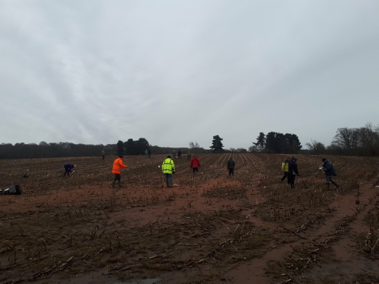
Picture: Volunteers field-
Picture: Volunteers field-
The finds from this project are still being analysed. The results will be made available when complete.
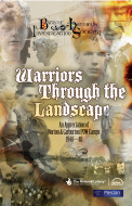
Heritage Lottery Funded “Warriors Through the Landscape” Project, 2018.
 In 2018 Merican and BOHIS also collaborated on the Heritage Lottery Funded “Warriors Through the Landscape”.
This amazing community archaeology project included a LiDAR Survey of the entire area between Church Warsop in the South to Whitwell Woods in the north, and from Creswell Crags in the west to Carburton in the east.
Volunteers were involved in a wonderful learning experience including archaeological excavation at Cuckney Castle, topographic survey of the Duke of Portland’s 19th century water meadow system, LiDAR ground -
There were also site vissits and classroom sessions with many of the local schools.
You can find out more at: http://battleofhatfieldsociety.co.uk/
The project included the production of two fabulous community books recounting the project and some of its findings:
 Warriors Through the Landscape -
Battle of Hatfield Investigation Society and Mercian Archaeological Services CIC, 2019.
http://battleofhatfieldsociety.co.uk/wp-
 Warriors Through the Landscape -
Battle of Hatfield Investigation Society, Bob Ilet, and Mercian Archaeological Services CIC, 2019.
http://battleofhatfieldsociety.co.uk/wp-
The excavation place to the west of the Cuckney Castle Scheduled monument.
The project report can be seen here:
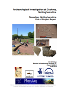 Archaeological Investigation at Cuckney, Nottinghamshire. Bassetlaw, Nottinghamshire. End of Project Report. Open Series Report.
David Budge, 2019.
http://www.mercian-
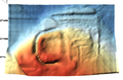
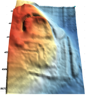
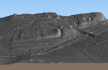 Picture: 3D LiDAR visualisation of Cuckney Castle and churchyard facing south
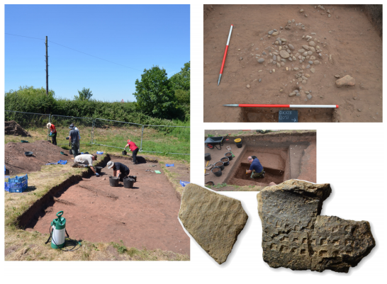
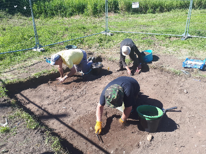
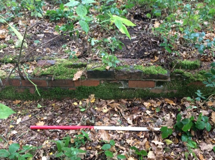
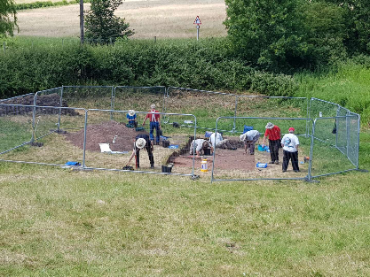 Picture: Community Archaeology excavation at Cuckney
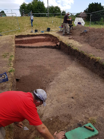 Picture: Community Archaeology excavation at Cuckney
 Picture: Community Archaeology excavation at Cuckney
 Picture: Community Archaeology excavation at Cuckney
For results from the excavation please see the report above
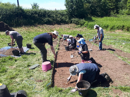
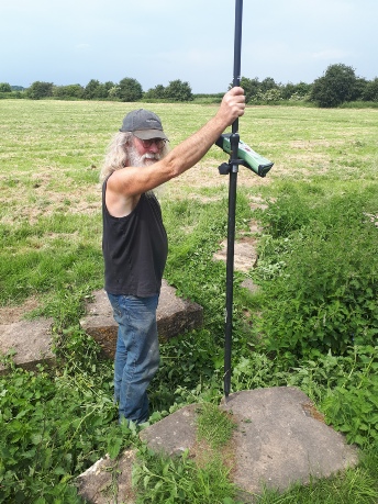
Archaeological test pits were excavated in Cuckney as part of investigating the development of the settlement.
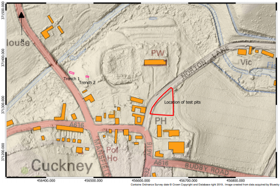
Picture: Areas of archaeological investigation at Cuckney as detailed in the report, in relation to the present settlement and the earthworks. Basemap combines hillshade and relief models of the topography produced from LiDAR data acquired by Bluesky.
Picture: Volunteer test-
Picture: Volunteer test-
Picture: Volunteer test-
Results from the test pitting can be seen in the end of project report above.
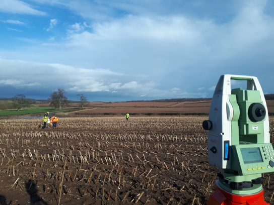
A survey of the Duke of Portand’s 19th century water meadow system at Cuckney was undertaken in the summer of 2018. Volunteers used EDM Total Station, Robotic EDM Total station, and Differential GPS to map the surface of the ground.
This level two survey was combined with a Level one survey of archaeological features to map and interpret the layout and use of the system.
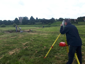 Picture: Community Archaeology volunteers surveying Cuckney water meadow system.
 Picture: Community Archaeology volunteers surveying Cuckney water meadow system.

Picture: 3D visualisation of LiDAR data showing the Cuckney water meadows system.
The results of the survey can be seen in the report:
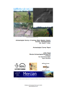 Archaeological Survey of Cuckney Water Meadow System, Cuckney, Nottinghamshire. Open Series Report.
Andy Gaunt, 2019.
http://www.mercian-
 Picture: LiDAR Digital Surface model (top) of Carburton Woods. Bottom image is Digital Terrain Model of the same location with the trees removed-
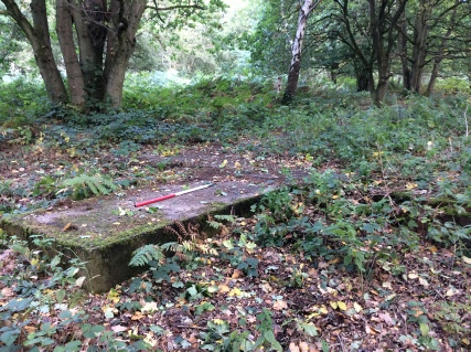 Picture: Concrete and brick hut platforms from the former prisoner of war camp.
 Picture: Concrete and brick hut platforms from the former prisoner of war camp.
 LiDAR Analysis & Ground-
Andy Gaunt, 2019.
http://www.mercian-
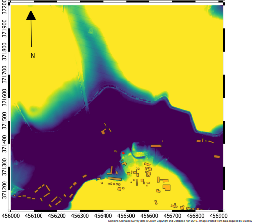
A survey of the landscape using Light Detectino and Ranging (LiDAR) was undertaken by Bluesky in the early summer of 2018.
The LiDAR was analysed by Mercian Archaeolgical Services and a report wa
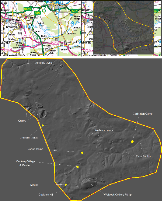
Picture: LiDAR survey area (see report).
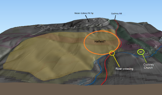
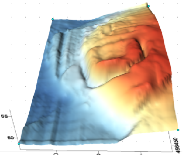
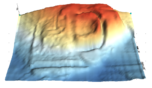
Picture: 3D visualisation of LiDAR data for Cuckney (see report below), showing the are of ‘Hatfield’ facing south. The area in brown represents ‘Hatfield’ as suggested from historic sources. Is this the site of the 7th century battle? The church and river crossing are highlighted, as is Cuckney hill to the south. The road is in red and the river in blue.
Picture: Using LiDAR to analyse the landscape of Cuckney Castle (see LiDAR report below).
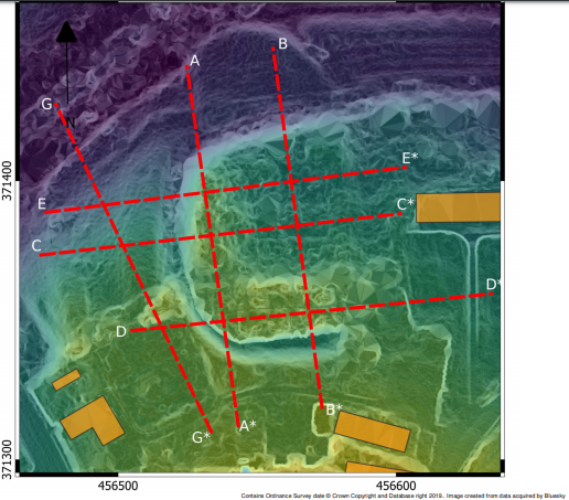
Picture: Using LiDAR to analyse the landscape of Cuckney Castle, developing cross sections (see LiDAR report below).
The LiDAR Survey results can be seen in the report:
LiDAR Analysis & Ground-
Andy Gaunt, 2019.
http://www.mercian-
2017 Edwinstowe Church Alignment Survey
 Edwinstowe means 'Edwin's Holy Place' and report by Mercian Archaeological Services CIC, as part of the Sherwood Forest Archaeology Project, has shown that Edwinstowe church, in the medieval period, pointed at the sunrise on the 12th October, which is the saint day of St Edwin.
See the project page here: http://mercian-
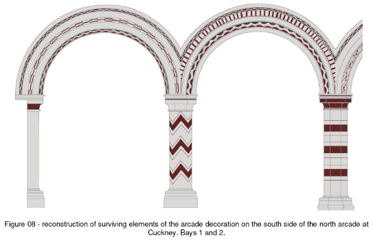
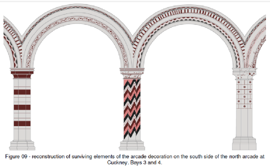
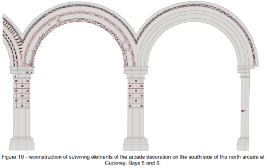
Cuckney Church Paintings Survey and Analysis.
In 2017,  Mercian have undertook a survey of Cuckney Church, which included a photogrammetric survey of medieval 12th century paintings on the north arcade of the church.
These were reconstructed in the report.
Mercian’s David Budge undertook a recording an analysis of late 12th century wall paintings in Cuckney Church. These are very rare indeed. The survey undertaken included a photogrammetric survey and resulted in a reconstruction of what the arcade may have looked like in it heyday.
The report can be seen here:
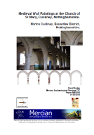 Medieval Wall Paintings at the Church of St Mary, Cuckney, Nottinghamshire. Norton Cuckney, Bassetlaw District, Nottinghamshire. Open Series Report.
David Budge, 2018.
http://www.mercian-
Images of the reconstructed arcade can be seen here:
 “Does the Heritage of the Welbeck Estate Include A King Killed At Cuckney?” Heritage Lottery Funded Project 2015
Mercian are very proud to announce the successful completion of our recent Heritage Lottery Fund sponsored project which we developed and worked on for the Battle of Hatfield Investigation Society.
“Does the Heritage of the Welbeck Estate Include A King Killed At Cuckney ?”
http://www.hlf.org.uk/our-
HLF Award Total: £15,600
 In 1951 burials were found under the church in the village of Cuckney a few mile northwest of Edwinstowe. It was suggested that these burials could have dated to the Battle of Hatfield. Mercian and BOHIS undertook a Heritage Lottery Funded Project in 2015 to investigate the site of these potential burials using non-
The results from the highly successful 2015 “Does the Heritage of the Welbeck Estate Include A King Killed At Cuckney?” HLF funded project can be seen below.
Match Funding for the project was also provided by:
![]()
 The project began with a launch BBQ on the 17th July 2015 and completed on the 31st March 2016 with the submission of the Archaeological reports from Mercian and lots of paperwork from BOHIS!
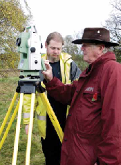 The project culminated in November 2015 with two weeks of fieldwork where Geophysical surveys and topographic surveys were conducted with the community to record the earthworks of the castle, and to search for burials possibly associated with the Saxon Battle of Hatfield fought in the year 633 between the armies of Mercian and Gwynedd, against King Edwin of Northumbira, who died in the battle.
Results from the project are available in the archaeological report below.
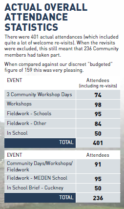
The project was a huge success with a large amount of community involvement including 401 attendees at a mixture of Community workshop days, workshops, Fieldwork, and school sessions…

All photographs come from the community project book by BOHIS chairman Paul Jameson available FREE as part of the project (click on the book)

Summary of the fieldwork:
In 1951 during underpinning works at Cuckney Church a large number of burials, all stated to be male, were found in a series of pits beneath the northern part of the parish church (Barley 1951).
The bodies were dug up, and subsequently re-
In 1977 Stanley Revel proposed a theory based on place name evidence that the burials may instead be from the Battle of Hatfield fought in 632/633AD by the forces of King Edwin of Northumbria, against an alliance between Cadwallon of Gwynedd, and King Penda of Mercia (Revill 1975).
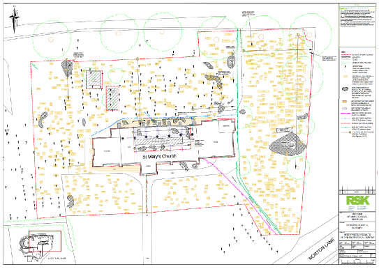
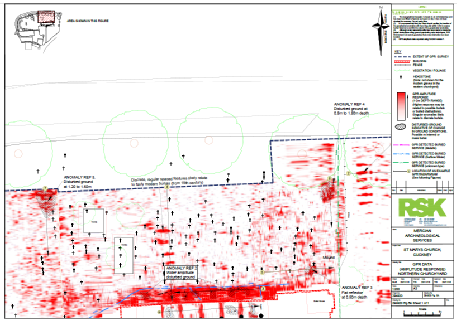
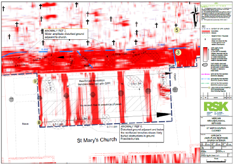
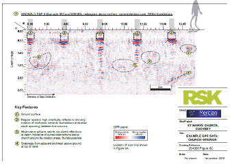
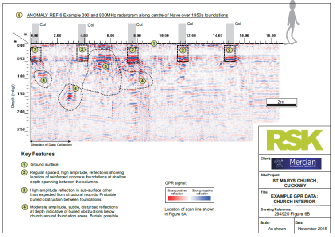
As part of a Heritage Lottery Funded project: Does the Heritage of the Welbeck Estate Include A King Killed At Cuckney? The Battle of Hatfield Investigation Society employed Mercian Archaeological Services CIC to lead an archaeological investigation to locate the possible burial pits, locate the possible reinterments from 1951, and to further interpret the site, earthworks and landscape; which includes the above mentioned medieval castle of Cuckney. This report contains the results of the integrated archaeological survey overseen by Mercian Archaeological Services CIC, which included a geophysical magnetometer survey and a topographic earthwork survey by Mercian, and a ground penetrating radar survey by RSK Geophysics. The Ground Penetrating Radar survey detected annomalies under the church which could represent burial pits, and also found anomalies in the eastern part of the churchyard which could represent the re-
During the surveys; two late Saxon pottery sherds were recovered from the site, one just to the east of the present church and the other approximately directly 215m west of the first, within the valley of the Poulter. These sherds represent the first archaeological evidence for late Saxon activity in Cuckney.
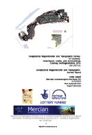
 An Integrated Archaeological Survey of Cuckney Churchyard, Castle, and surroundings. Cuckney, Nottinghamshire, 2016. Archaeological Report [94.9MB].
http://www.mercian-
The project was designed an undertaken as a community archaeology project with volunteers receiving training and experience in archaeological techniques, learning about local heritage, and helping with the survey.

Other reports:
(also in Appendices of main report above)
 Geophysical Magnetometer and Topographic Surveys of Cuckney Churchyard, Castle, and surroundings.
Cuckney, Nottinghamshire, 2016. Archaeological Report. [5.83MB]
Andy Gaunt
http://www.mercian-
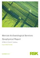 RSK Geophysics
Ground Penetrating Radar Survey Report
Cuckney, Nottinghamshire, 2016. Archaeological Report. [8.39MB]
http://www.mercian-

Mercian would like to thank everyone who has been involved in this project including:
All the fantastic volunteers who came and joined in…
The school children, teachers and helpers at Meden Vale, and Cuckney Church of England Primary Schools,
All those who attended workshops, meetings and presentations throughout the project…
We would also like to thank the Battle of Hatfield Investigation Society for all their hard work, and in particular the Chairman Paul Jameson and Honorary President Joseph Waterfall for their boundless enthusiasm, driving force and dedication, having provided hundreds of hours of their time to this project and the overall research of the society…
We also thank Tim Allen Inspector of Ancient Monuments, and Erin Lewis, Business Officer, Historic England.
The Diocese of Southwell & Nottingham.
Rev. Simon Cash and the Parochial Church Council of St. Mary’s Church, Cuckney.
The Welbeck Estate.
Ursilla Spence, Principal Archaeologist, Nottinghamshire County Council, for supporting the project (and providing the map from the previous unfinished church yard survey undertaken by Nottinghamshire County County Community Archaeology).
Some results from the report:
Magnetometer survey
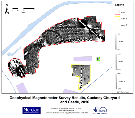 Picture: Results from Magnetometer Survey 2016. Contains OS data © Crown copyright [and database right] 2016. © Mercian Archaeological Services CIC, 2016.
Please see the report for details and description.
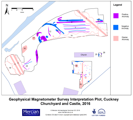 Picture: Interpretation plot of Geophysical Magnetometer survey 2016. Contains OS data © Crown copyright [and database right] 2016. © Mercian Archaeological Services CIC, 2016.
Please see the report for details and description.
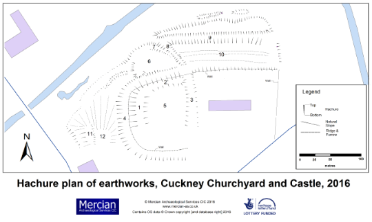
Picture: Hachure plan and map of topographic earthwork survey 2016. Contains OS data © Crown copyright [and database right] 2016. © Mercian Archaeological Services CIC, 2016.
Please see the report for details and description.
Topographic survey
 Picture: Digital Terrain Model of the results from the topographic survey of Cuckney Churchyard, castle and surrounds. North is to the top. © Mercian Archaeological Services CIC, 2016.
 Picture: Digital Terrain Model of the results from the topographic survey of Cuckney Churchyard, castle and surrounds. North is to the top. © Mercian Archaeological Services CIC, 2016.
Please see the report for details and description.
 Picture: Digital Terrain Model of the results from the topographic survey of Cuckney Churchyard, castle and surrounds. West is to the top. © Mercian Archaeological Services CIC, 2016.
Please see the report for details and description.
 Picture: Digital Terrain Model of the results from the topographic survey of Cuckney Churchyard, castle and surrounds. East is to the top. © Mercian Archaeological Services CIC, 2016.
Please see the report for details and description.
Picture: Digital Terrain Model of the results from the topographic survey of Cuckney Churchyard, castle and surrounds. South is to the top. © Mercian Archaeological Services CIC, 2016.
Please see the report for details and description.
Ground Penetrating Radar (GPR) survey
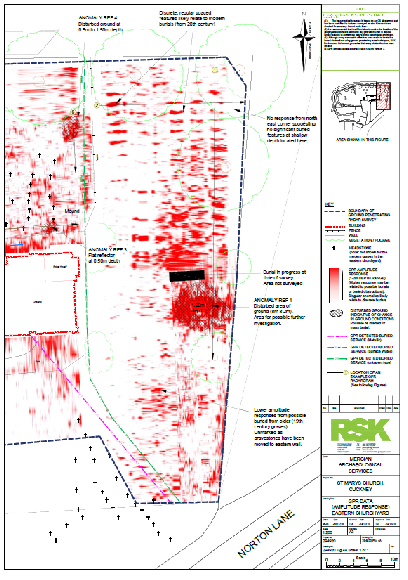
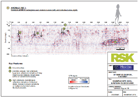
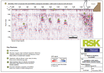
Picture: Eastern half of interpreted results from the Geophysical Ground penetrating Survey, Cuckney 2016. © RSK Environment Ltd.
Please see the report for details and description.
 Picture: Results from the Geophysical Ground penetrating Survey, Cuckney 2016. © RSK Environment Ltd.
Please see the report for details and description.
 Picture: Results from the Geophysical Ground penetrating Survey, Cuckney 2016. © RSK Environment Ltd.
Please see the report for details and description.
 Picture: Results from the Geophysical Ground penetrating Survey, Cuckney 2016. © RSK Environment Ltd.
Please see the report for details and description.
 Picture: Results from the Geophysical Ground penetrating Survey, Cuckney 2016. © RSK Environment Ltd.
Please see the report for details and description.
 Picture: Results from the Geophysical Ground penetrating Survey, Cuckney 2016. © RSK Environment Ltd.
Please see the report for details and description.
 Picture: Results from the Geophysical Ground penetrating Survey, Cuckney 2016.
© RSK Environment Ltd.
Please see the report for details and description.
 Picture: Results from the Geophysical Ground penetrating Survey, Cuckney 2016. © RSK Environment Ltd.
Please see the report for details and description.
2015 Cuckney Churchyard Survey
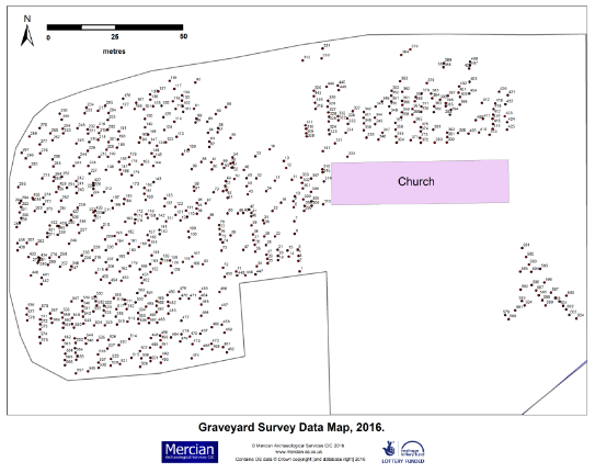
Picture: Gravestone location map, 2016. Contains OS data © Crown copyright [and database right] 2016. © Mercian Archaeological Services CIC, 2016.
Please see the report for details and description.
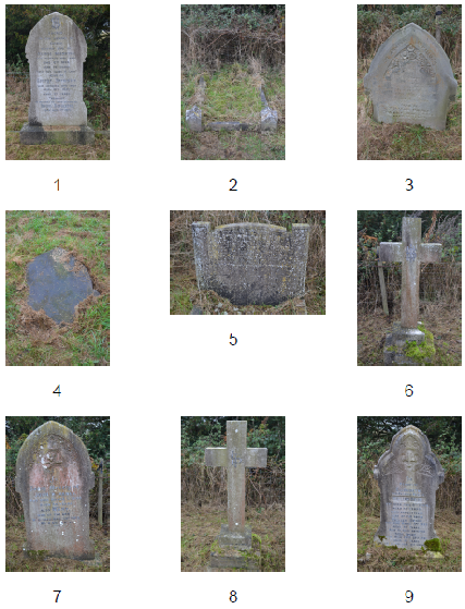 Picture: Example gravestone photographs 2016.
Please see the report for details and description.
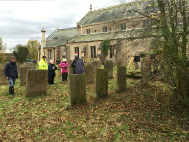 Picture: Volunteers undertaking graveyard survey 2016
Please see the report for details and description.
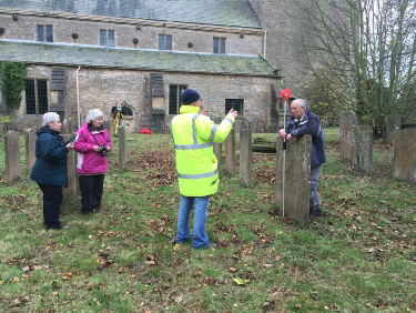 Picture: Volunteers undertaking graveyard survey 2016
Please see the report for details and description.
 From 2014 onwards Mercian have also undertaken fieldwalking, geophysical survey, and top-
All these projects are part of Mercian’s long-
Some media coverage of the project:
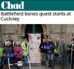 Mansfield Chad Thursday 12th November 2015
A group of archaeologists are a step nearer discovering whether 200 buried skeletons will prove an ancient battle took place near Warsop.
Three shadowy hotspots found by ground penetrating radar could finally have pinpointed the location of the remains which could completely rewrite the history of the Battle of Hatfield.
Volunteers from The Battle of Hatfield Investigation Society (BOHIS) are taking part in the first fieldwork they hope could relocate the site of the death of Edwin -
A whole community including around 100 schoolchildren from Meden and Cuckney Schools are taking part in the eight day project which will examine 1,400 years of the area’s history.
BOHIS was recently awarded £15,600 Heritage Lottery Fund (HLF) support to explore and share the history of Cuckney Norton and Holbeck.
Read more: http://www.chad.co.uk/news/local/battlefield-
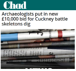 Mansfield Chad Saturday 2nd May 2015
A group of archaeologists have made their final bid for a £10,000 investigation to discover whether 200 buried skeletons will prove an ancient battle took place near Warsop.
The Battle of Hatfield Investigation Society (BIOHIS) hopes to rewrite the history of the Battle of Hatfield and relocate the site of the death of Edwin -
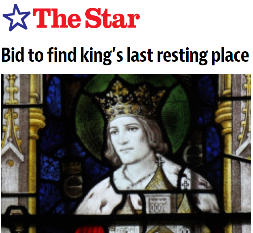 Sheffield Star Wednesday 30th October 2013
The spot where an Anglo-
King Edwin, who ruled Northumbria, was thought to have been killed at the Battle of Hatfield Chace, north of Doncaster, in 632AD.Read more:
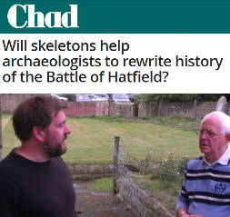 Mansfield Chad Wednesday 2nd October 2013.
With the discovery of the remains of Richard III under a council carpark in Leicester last year and the subsequent row between the city and the people of York about where he should be laid to rest -
Despite the antics of screen archaeologists, it is a meticulous science that relies on the detailed study of artefacts, buildings and local geography to eek out the clues of the past.
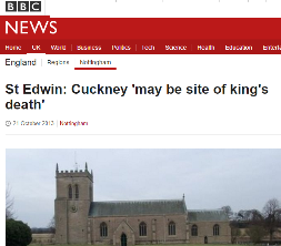 BBC News Tuesday 22nd October 2013
A full excavation of a Nottinghamshire church's grounds could prove where an Anglo-
The Battle of Hatfield Investigation Society believes St Edwin died at Cuckney, near Mansfield in AD632 and not in Yorkshire as has been claimed.
Their theory is based on 200 skeletons found beneath St Mary's Church in Cuckney in 1951.
Read more: http://www.bbc.co.uk/news/uk-
Project page links:
-
-
-
-
-
-
-
-
The Sherwood Forest
National Nature Reserve Archaeology Survey
-
Long term Research at
King John’s Palace:
Ancient Royal Heart of Sherwood Forest
-
The Sherwood Forest Archaeology Training Fieldschool
-
“Scirwuda-
Ghost and Shadow woods of Sherwood Forest Project
-
Investigating Thynghowe Viking
Meeting Site
-
Searching for the
The Battle of Hatfield
-
-
Fieldswork at St Edwin’s Chapel
-
St Mary’s Norton-
-
Mapping Medieval Sherwood Forest
-
The Sherwood Forest LiDAR
Project
-
Warsop Old Hall
Archaeological Project
-
The Sherwood Villages Project:
Settlement Development in the Forest
-
-
-
Researching Edward IIs fortification at Clipstone Peel
-
-
-
-
The Cistercians of Rufford Project:
Settlement Development, Dynamics and Desertion.
-
Sherwood Forest Environmental Survey
-
World War II in Sherwood Forest -
-
World War I in Sherwood Forest -
-
About Medieval Sherwood Forest
-
Robin Hood and Sherwood Forest
-
-
-
-
-
-
-
-
-
-
-
-
Community Archaeology in Derbyshire
Community Archaeology in Leicestershire
Community Archaeology Nottinghamshire, Excavation, Research, Volunteering, Community Archaeology Derbyshire, Training, Social, Learning, Community Archaeology Leicestershire, Heritage, Involvement, Belonging, Knowledge sharing, Community Archaeology Lincolnshire, Topographic Survey, Talks and Presentations, Outreach, Archaeology Projects , Open Days, Schools, Finds Processing, Day Schools, Field Schools, Young People, Archaeology and History of Sherwood Forest, Pottery Research, Medieval, Roman, Prehistoric, Community Interest Company, Community Archaeology Nottinghamshire.
Community Archaeology in Nottinghamshire
Community Archaeology East Midlands
Community Archaeology in Lincolnshire
Community Archaeology in Yorkshire
Mercian Archaeological Services CIC
Specialists in Community Archaeology, Public Involvement, Research & Training
© Mercian Archaeological Services CIC 2024. Registered Business No. 08347842. All Rights Reserved.


The Future of Sherwood’s Past


Community Archaeology Nottinghamshire, Community Archaeology Derbyshire, Community Archaeology Leicestershire, Community Archaeology East Midlands, Mercian Archaeological Services Community Archaeology for Nottinghamshire, Derbyshire, Sherwood Forest, Leicestershire and the East Midlands. Community Archaeology Nottinghamshire, Community Archaeology East Midlands, Community Archaeology Leicestershire. Archaeological
The Battle of Hatfield -