The Cistercian’s of Rufford Project is a landscape and settlement development research project, devised by Mercian to understand amongst other things; the 12th century settlement pattern of Sherwood Forest.
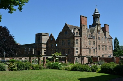
Picture: Rufford Abbey today
Rufford Abbey was founded by Gilbert de Gant in 1146.
The charter confirming the foundation was granted by King Stephen on Christmas day of that year.
Rufford was a Cisterican Monastery, a daughter house of Riveaulx Abbey in Yorkshire.
The abbey was situated just to the West of the King's Highway to York which passed from Nottingham northwards through Sherwood Forest, and the Abbey was an attractive stop-
The Abbey sat towards the northern edge of a vast tract of heathland, meadow, woodland and farmland consolidated from the possessions of the villages of Rufford, Crately, and Inkersall, granted to the Abbey. Rufford village had 8 families when the monks arrived, but was abandoned by the end of the Thirteenth Century. Crately was slower to become deserted, but villagers eventually moved to settle in nearby Edwinstowe and the village of Wellow.
It is this forced desertion of the surrounding villages that offers a potential window into the nature of settlement development up to the later 12th century.
If these settlements were abandoned at that time, they may give clues to how villages were chosen, developed, what were the dynamics of the village morphology, and what happened on desertion.
The village of Wellow, supposedly founded in the late 12th century, which developed though the 13th century to include a market, planned layout and surrounding bank and ditch is being investigated as part of the concurrent “Landscape of Wellow Project”. Results from the two projects are an essential and key part of the Sherwood Forest Archaeology Project and its research aims of understanding the settlement development of the area.
This exciting project includes documentary research, historic mapping, and more, and will hopefully include fieldwork over the coming years.
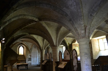
Picture: Mercian Archaeological Services CIC, Groin-
The Church of the Abbey was dedicated to St Mary, and was built in the remote wastes and woods of Sherwood by the Cistercians, who favoured the isolation and separation from the world provided by the forest.
The Abbey complex included the Church, Cellar, Lay Brothers Frater, Cloister, Kitchens, Monks Frater, Warming House, Undercroft and Dormitory above, Inner Parlour, Chapter House, and Sacristy.
The surrounding landscape included areas of Woodland: 'ye abote wode', 'Abott Ymmslow', and 'burne abotote wode'. There were also large areas of heather lyngges, or wastes known as 'the Forest'. The valley of the Rainworth Water to the south of the Abbey was managed as Meadows to provide winter fodder for large numbers of sheep. The Cistercians were prolific sheep farmers.
The Abbey organised much of these land-
As well as the demense farming which provided income for the Abbey, the Monks also possessed large parts of the town of Rotherham in Yorkshire which provided a vast amount of taxable income for the Abbey.
The Abbey was a popular over night resting place on the great road through the Forest and would have provided welcome accommodation as night fell over the desolate heaths and remote woodland of the High Forest.
Accommodation was provided for free by the monks-
These could include Royalty, and in 1290 Queen Eleanor of Castile, wife of King Edward I stayed here while Edward held Parliament at his nearby Royal Palace and Hunting lodge at Clipstone. In fact the Abbey was among her final resting places as she was ill during her stay there, and died during an attempt to move to Lincoln for Spiritual and Medical help.
Rufford was a part of the fabric of life in Sherwood Forest for 400 hundred years.
It would sadly come to an end in the 1530 under King Henry VIII along with all other monasteries in the Kingdom.
At the Dissolution of the Monastery the Abbot was accused of being incontinent with two married women and 4 single women-
Despite this inglorious ending, Rufford Abbey passed into the hands of rich landowners and eventually emerged to become a Country Park in the present Day with parts of the Medieval Abbey surviving within the later house. These include the Lay Brothers Frater and the Undercroft which can still be visited to this day.
Project page links:
-
-
-
-
-
-
-
-
The Sherwood Forest
National Nature Reserve Archaeology Survey
-
Long term Research at
King John’s Palace:
Ancient Royal Heart of Sherwood Forest
-
The Sherwood Forest Archaeology Training Fieldschool
-
“Scirwuda-
Ghost and Shadow woods of Sherwood Forest Project
-
Investigating Thynghowe Viking
Meeting Site
-
Searching for the
The Battle of Hatfield
-
-
Fieldswork at St Edwin’s Chapel
-
St Mary’s Norton-
-
Mapping Medieval Sherwood Forest
-
The Sherwood Forest LiDAR
Project
-
Warsop Old Hall
Archaeological Project
-
The Sherwood Villages Project:
Settlement Development in the Forest
-
-
-
Researching Edward IIs fortification at Clipstone Peel
-
-
-
-
The Cistercians of Rufford Project:
Settlement Development, Dynamics and Desertion.
-
Sherwood Forest Environmental Survey
-
World War II in Sherwood Forest -
-
World War I in Sherwood Forest -
-
About Medieval Sherwood Forest
-
Robin Hood and Sherwood Forest
-
-
-
-
-
-
-
-
-
-
-
-
Community Archaeology in Derbyshire
Community Archaeology in Leicestershire
Community Archaeology Nottinghamshire, Excavation, Research, Volunteering, Community Archaeology Derbyshire, Training, Social, Learning, Community Archaeology Leicestershire, Heritage, Involvement, Belonging, Knowledge sharing, Community Archaeology Lincolnshire, Topographic Survey, Talks and Presentations, Outreach, Archaeology Projects , Open Days, Schools, Finds Processing, Day Schools, Field Schools, Young People, Archaeology and History of Sherwood Forest, Pottery Research, Medieval, Roman, Prehistoric, Community Interest Company, Community Archaeology Nottinghamshire.
Community Archaeology in Nottinghamshire
Community Archaeology East Midlands
Community Archaeology in Lincolnshire
Community Archaeology in Yorkshire
Mercian Archaeological Services CIC
Specialists in Community Archaeology, Public Involvement, Research & Training
© Mercian Archaeological Services CIC 2024. Registered Business No. 08347842. All Rights Reserved.


The Future of Sherwood’s Past


Community Archaeology Nottinghamshire, Community Archaeology Derbyshire, Community Archaeology Leicestershire, Community Archaeology East Midlands, Mercian Archaeological Services Community Archaeology for Nottinghamshire, Derbyshire, Sherwood Forest, Leicestershire and the East Midlands. Community Archaeology Nottinghamshire, Community Archaeology East Midlands, Community Archaeology Leicestershire. Archaeological
The Cistercians of Rufford Abbey Project -