The Sherwood Forest LiDAR project has been underway for a number of years.
So far the project has built a comprehensive Geographic Information Systems (GIS) containing all the 2m, 1m and 0.5m Digital Terrain Model (DTM) and 2m, 1m and 0.5m Digital Surface Model (DSM) data available for Historic Sherwood Forest landscape (as defined in the ‘Project Study Area’ section of the About the Project Page.
The project had also included in the GIS the 0.25m LiDAR data provided courtesy of the Friends of Thynghowe for the area centring on the Viking Meeting Site of Thynghowe; and the 0.25m LiDAR data set of the area between Church Warsop and Whitwell Woods provided courtesy of the Battle of Hatfield Investigation Society.
These two data set were flown as part of projects funded by the Heritage Lottery Fund, and the data was provided by both organisations mentioned above to allow further research of the Sherwood Forest landscape via the Sherwood Forest LiDAR Project.
The project GIS has enabled a study of the data for archaeological remains within the Forest area and forms a large part of the data for analysing settlements as part of the ongoing Sherwood Villages Project, Sherwood Forest in World War II project, the Sherwood Forest in World War I project, the Medieval Map of Sherwood Forest, The Sherwood Forest National Nature Reserve Survey and much more besides.
The project has also demonstrated gaps and calculated percentages of coverage and highlighted areas requiring future surveys.
0.5m resolution LiDAR coverage in the Sherwood Forest Area:
The following map shows the extent of coverage at 0.5m resolution, within the Sherwood Forest landscape. This map is an extract from the Sherwood Forest LiDAR GIS database.
The LiDAR data set below alongside coverage at 1m, 2m and 0.25m resolution is being used to identify potential archaeological features. The aim is to ground-

Picture: Area of coverage of LiDAR data at 0.5m resolution (in red hatched area). Contains Ordnance Survey data © Crown copyright and database right 2019.
1m resolution LiDAR coverage in the Sherwood Forest Area:

Picture: Area of coverage of LiDAR data at 1m resolution (in blue hatched area). Contains Ordnance Survey data © Crown copyright and database right 2019.
0.5m and 1m resolution combined LiDAR coverage in the Sherwood Forest Area:

Picture: Area of coverage of LiDAR data at 0.5m and 1m resolution combined (0.5m in red hatched area, 1m in blue). Contains Ordnance Survey data © Crown copyright and database right 2019.
Visit DEFRA website to download data files: https://environment.data.gov.uk/DefraDataDownload/
The Sherwood Forest LiDAR Project has enabled LiDAR to be used in the surveying, and analysis of landscpaes and archaeological features in many of the other projects in the Sherwood Forest Archaeology Project.
These include (among many others):
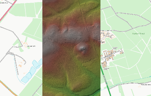
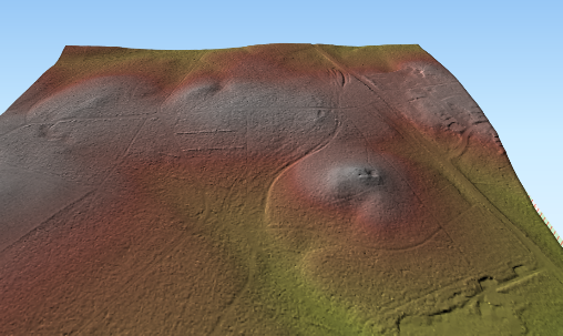
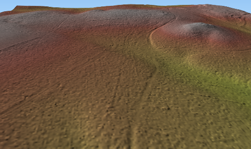
The Sherwood Forest National Nature Reserve Archaeology Survey:

Picture: Preliminary results from The Sherwood Forest National Nature Reserve Archaeological Survey. The image is a LiDAR Composite DTM -
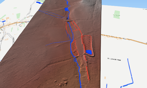
Cuckney and the Battle of Hatfield:
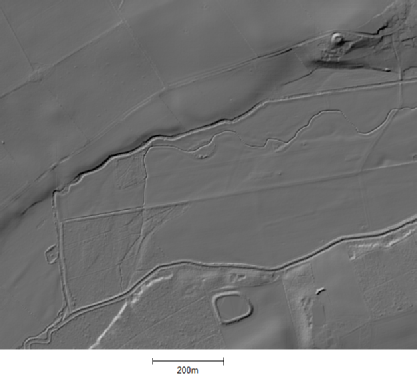
Cuckney water meadows system:

Picture: LiDAR analysis of Cuckney Water meadow system.
Carburton Prisoner of War Camp:

Picture: LiDAR Digital Surface model (top) of Carburton Woods. Bottom image is Digital Terrain Model of the same location with the trees removed-
Why not help us to find more?
If you have a site you are interested in we can help you to discover if it is covered by LiDAR and cast our archeological eye over it for you.
Please contact Mercian at info@mercian-
Below is a small example of the archaeological elements so far analysedd as part of the project:
The Hayman Rooke Enclosure -
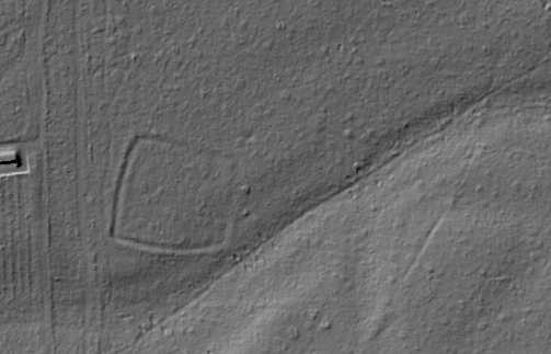
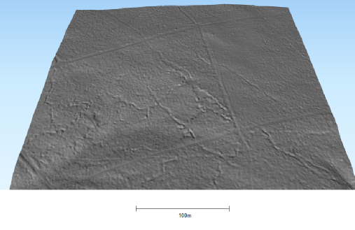
Picture; The Hayman Rooke Enclosure, in the Sherwood Forest National Nature Reserve, the enclosure is roughly 100m. It was re-
Picture; 3D rendering of the Hayman Rooke Enclosure, in the Sherwood Forest National Nature Reserve, viewed from the South, the enclosure is roughly 100m across. It was re-
Moor Pond Wood Papplewick -
The area of Moor Pond Woods, where the Robinson family developed a series of ponds and interconnecting leets along the River Leen to power cotton mills, in the 18th century. Water-
LiDAR Composite DTM -
Picture: 3D visualisation of the area of Moor Pond Woods, where the Robinson family developed a series of ponds and interconnecting leets along the River Leen to power cotton mills, in the 18th century. Water-
LiDAR Composite DTM -
Picture: 3D visualisation of the area of Moor Pond Woods, where the Robinson family developed a series of ponds and interconnecting leets along the River Leen to power cotton mills, in the 18th century. Water-
LiDAR Composite DTM -
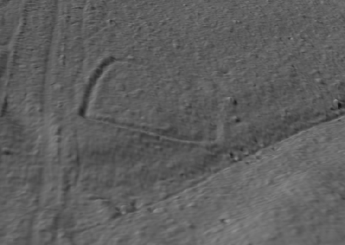
Galow Tre Hill (Gallow Tree Hill) -
In Thieves Wood , south of Mansfield lies a mound listed on the Nottinghamshire Historic Envronment Record (HER) as a Bronze Age Burial Mound. This mound has been been interpreted by Andy Gaunt of Mercian Archaeological Services, and Alan McCorkmack as the location of ‘Galow Tre Hyl’ shown on the late 14th to early 15th century Belvoir Map of Sherwood Forest. This would have been the town gallows for Mansfield in the medieval period and would have utilised the already present burial mound.
The holloway forming the route of the old Mansfield Road can bee seen to circumventing the mound on the western side-
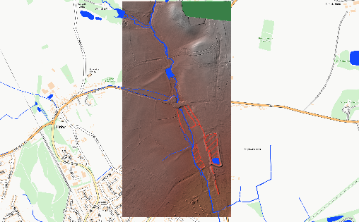
Picture: Map of the area of Thieves Wood, Mansfield. A mound listed on the Nottinghamshire Historic Envronment Record (HER) as a Bronze Age Burial Mound. This mound has been been interpreted by Andy Gaunt of Mercian Archaeological Services, and Alan McCorkmack as the location of ‘Galow Tre Hyl’ shown on the late 14th to early 15th century Belvoir Map of Sherwood Forest. This would have been the town gallows for Mansfield in the medieval period and would have utilised the already present burial mound.
LiDAR Composite DTM -
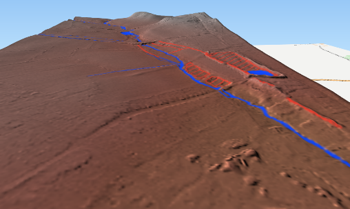
Picture: 3D visualisation of Thieves Wood, Mansfield. A mound listed on the Nottinghamshire Historic Envronment Record (HER) as a Bronze Age Burial Mound. This mound has been been interpreted by Andy Gaunt of Mercian Archaeological Services, and Alan McCorkmack as the location of ‘Galow Tre Hyl’ shown on the late 14th to early 15th century Belvoir Map of Sherwood Forest. This would have been the town gallows for Mansfield in the medieval period and would have utilised the already present burial mound. Viewed from the south. The holloway forming the route of the old Mansfield Road can bee seen to circumventing the mound on the left hand side-
LiDAR Composite DTM -
Picture: 3D visualisation of Thieves Wood, Mansfield. A mound listed on the Nottinghamshire Historic Envronment Record (HER) as a Bronze Age Burial Mound. This mound has been been interpreted by Andy Gaunt of Mercian Archaeological Services, and Alan McCorkmack as the location of ‘Galow Tre Hyl’ shown on the late 14th to early 15th century Belvoir Map of Sherwood Forest. This would have been the town gallows for Mansfield in the medieval period and would have utilised the already present burial mound. Viewed from the southwest. The holloway forming the route of the old Mansfield Road can bee seen to circumventing the mound on the left hand side-
LiDAR Composite DTM -
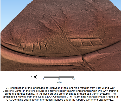
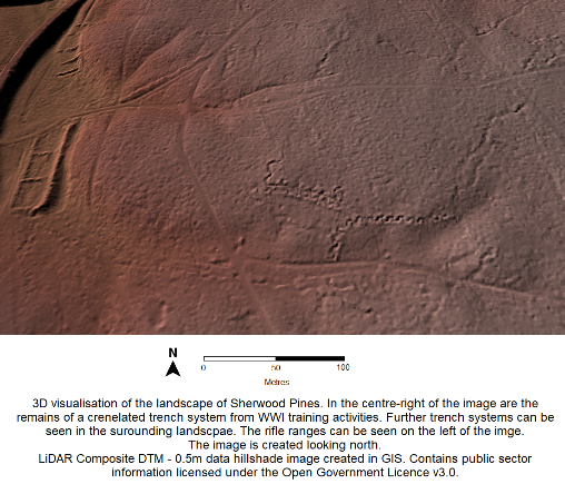
Sherwood Pines-
Picture; 3D rendering of First World War training systems, in Sherwood Pines, viewed from the west, the trenches formed part of the Clipstone Camp training area, and are just a part of the remains from the training area that survive under the Forestry Commission plantation. LiDAR Composite DTM -
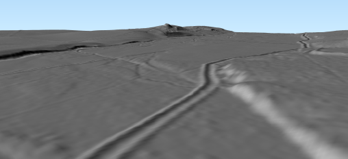
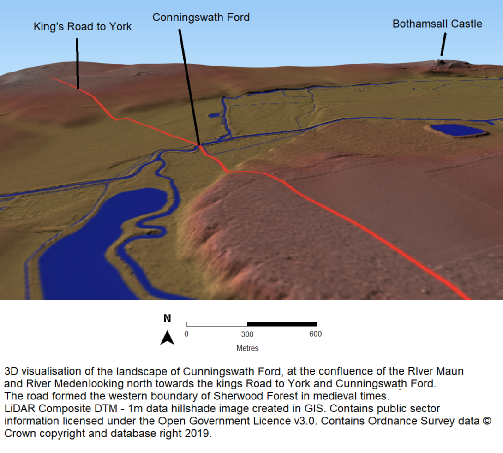
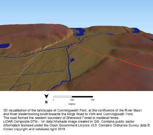
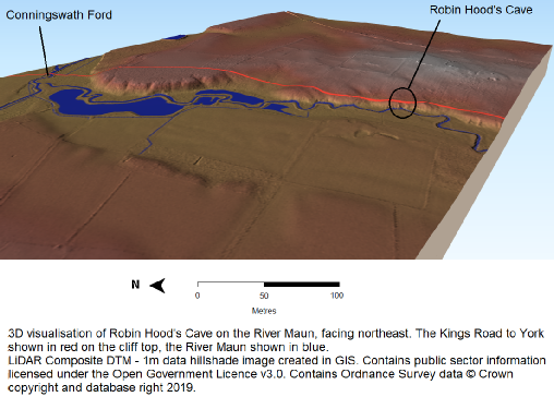
Picture: Bothamsall Castle Motte seen in northeast corner of image, Cunningswath Ford out of shot slightly to the southwest, where the Kings Road to York Crossed the confluence of the River Meden and River Maun. This was the northeastern corner of the 13th century Forest, and the starting point of the medieval perambulations of Sherwood Forest. Bothamsall castle watches over this important local strategic location. Viewed from the southwest. LiDAR Composite DTM -
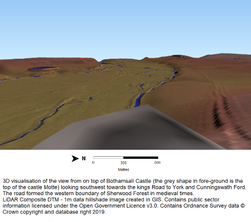
Picture: Bothamsall Castle Motte seen on ridge in distance from the Cunningswath Ford, where the Kings Road to York Crossed the confluence of the River Meden and River Maun. This was the northeastern corner of the 13th century Forest, and the starting point of the medieval perambulations of Sherwood Forest. Bothamsall castle watches over this important local strategic location. Viewed from the southwest. LiDAR Composite DTM -
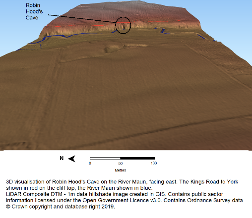
Robin Hood’s Cave
Gunthorpe Henge
Picture: Gunthorpe Henge facing north.
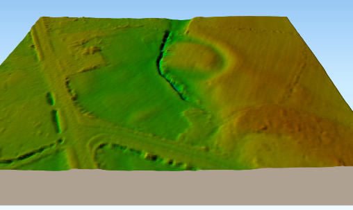
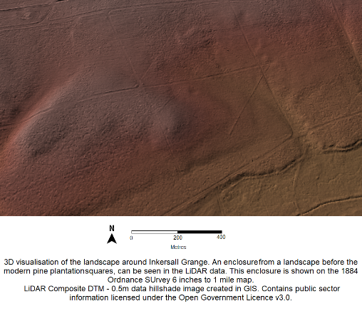
Inkersall Grange

Project page links:
-
-
-
-
-
-
-
-
The Sherwood Forest
National Nature Reserve Archaeology Survey
-
Long term Research at
King John’s Palace:
Ancient Royal Heart of Sherwood Forest
-
The Sherwood Forest Archaeology Training Fieldschool
-
“Scirwuda-
Ghost and Shadow woods of Sherwood Forest Project
-
Investigating Thynghowe Viking
Meeting Site
-
Searching for the
The Battle of Hatfield
-
-
Fieldswork at St Edwin’s Chapel
-
St Mary’s Norton-
-
Mapping Medieval Sherwood Forest
-
The Sherwood Forest LiDAR
Project
-
Warsop Old Hall
Archaeological Project
-
The Sherwood Villages Project:
Settlement Development in the Forest
-
-
-
Researching Edward IIs fortification at Clipstone Peel
-
-
-
-
The Cistercians of Rufford Project:
Settlement Development, Dynamics and Desertion.
-
Sherwood Forest Environmental Survey
-
World War II in Sherwood Forest -
-
World War I in Sherwood Forest -
-
About Medieval Sherwood Forest
-
Robin Hood and Sherwood Forest
-
-
-
-
-
-
-
-
-
-
-
-
Community Archaeology in Derbyshire
Community Archaeology in Leicestershire
Community Archaeology Nottinghamshire, Excavation, Research, Volunteering, Community Archaeology Derbyshire, Training, Social, Learning, Community Archaeology Leicestershire, Heritage, Involvement, Belonging, Knowledge sharing, Community Archaeology Lincolnshire, Topographic Survey, Talks and Presentations, Outreach, Archaeology Projects , Open Days, Schools, Finds Processing, Day Schools, Field Schools, Young People, Archaeology and History of Sherwood Forest, Pottery Research, Medieval, Roman, Prehistoric, Community Interest Company, Community Archaeology Nottinghamshire.
Community Archaeology in Nottinghamshire
Community Archaeology East Midlands
Community Archaeology in Lincolnshire
Community Archaeology in Yorkshire
Mercian Archaeological Services CIC
Specialists in Community Archaeology, Public Involvement, Research & Training
© Mercian Archaeological Services CIC 2024. Registered Business No. 08347842. All Rights Reserved.


The Future of Sherwood’s Past


Community Archaeology Nottinghamshire, Community Archaeology Derbyshire, Community Archaeology Leicestershire, Community Archaeology East Midlands, Mercian Archaeological Services Community Archaeology for Nottinghamshire, Derbyshire, Sherwood Forest, Leicestershire and the East Midlands. Community Archaeology Nottinghamshire, Community Archaeology East Midlands, Community Archaeology Leicestershire. Archaeological
Sherwood Forest LiDAR Project -