Sherwood Forest is a landscape of myths and legends famous around the world.
But where was Sherwood Forest? What was a Forest? How was it administered? What was it for ? How did it function? and Who lived there?
Sherwood Forest was primarily set up us a hunting ground for the King and his royal followers to enjoy hunting beasts of the chase such as deer.
This required a landscape of woodland and open heath land to accommodate the hunting of deer on horseback with hounds through a technique known as Par force de cheins.
Along side this chase there were many other forms of hunting that required varying landscapes such as the hunting of Fallow deer in parks through a method known as Bow and Stable.
These landscapes were wild romantic places associated with the romance legends of the day, including the adventures of Gawain and the Green Knight and King Arthur. Heroes of the elite.
These landscape s also formed the hiding place of outlaws and rebels which in turn gave rise to the legends of Robin Hood. Hero of the common man.
As well as providing a landscape of hunting, romance, outlaws and legends, the Forest had a complex legal system and court structure administering it, complete with with, foresters, keepers, judges, verders and agisters (tax collectors)… and of course poachers…
At the centre of the Forest was a royal Palace at Clipstone where parliaments were held and all 8 king from Henry II to Richard II visited and stayed.
In the south was Nottingham with its castle known as the gateway to the north, and an number of highways took travellers through the heart of the forest as they journeyed through the middle of England.
The forest was also home to many hundreds of ordinary people who made their lives from the land and tilled the land and raised animals in the heaths and woods.
The Sherwood Forest Archaeology Project seeks to investigate the lives and relationships that existed across Sherwood Forest, from the kings to the common man, from the keepers to the poachers, from the ancient trees and heaths to the courts and villages that dotted the land, and formed the life of this landscape of legends…
The Legal Forest:
Forest in medieval times was an area of land subject to Forest Law.
The Forest Law protected Beasts of the chase (primarily Deer) from being hunted, by anyone except the king unless he gave them permission.
It also protected the Woodland and habitat in which they lived.
It was therefore illegal to hunt deer or to chop down trees and underwood within a Forest.
The Forest law was another layer of administration that people had to obey.
The first surviving legal texts relating to the forest laws come from 1100.This is at the very start of the reign of Henry I
Offences included:
Clearing of land
Cutting of wood
Burning
Hunting,
Carrying of bows and spears in the forest
Loosing of livestock
There were also rules regarding:
The hambling of dogs
Discovery of hide or flesh
(Hambling of dogs meant the removal of claws to prevent the dog from hunting).
Law Enforcement:
Every forest in England was overseen by a Keeper.
This person was appointed directly by the king.
In Sherwood Forest the Keepership of the Forest was hereditary.
The De Caux and through marriage the D'Everingham families were hereditary keepers of the Forests of Nottinghamshire until 1286.
Following this the keepership was granted at the kings pleasure, and was usually given along with Stewardship of Nottingham Castle.
The keepers of the forest were responsible for policing the forest: they hired Foresters and agisters to act as a police force.
Foresters had the power to arrest people for infringements on the forest law. They patrolled the forest on horseback and on foot.
Agisters were tax collectors who adminstered rents and checked quotas relating to the grazing of animals (agistment) in the woods of the forest.
When someone had broken the law, a system of courts was required to punish the assailant.
Courts of the Forest:
There were a number of courts in the forest these included
Small fines court -
Major less frequent court – Forest Eyres for exacting justice on larger and more serious breaches.
Attachment court:
The attachment court was where judgment was passed on small cases of trespass on the vert and fines were issued.
In Sherwood Forest there were four such courts:
Linby ,
Calverton,
Mansfield,
and Edwinstowe
They met every 40 days at these locations, and were sometimes called the 40 day courts.
The Attachment court officials were known as Verderers.
This was a Privileged role-
Verderers had to be landowners within the forest to qualify for the position.
There were usually 4 per forest, but in Sherwood there were 6.
The roll of the 1292-
green oak was usually valued at 6d
a dry oak at 4d
a sapling from 1d to 3d
and stubb, or dry trunk of a pollard tree at 2d.
Forest Eyre:
The Forest Eyres were attended by itinerant justices, and were often named after the justices themselves,
eg. 1187 forest Eyre was known as the Eyre of Geoffrey Fitzpeter.
The Eyre dealt with extracting fines and levies from larger breaches of the forest law.
eg. In 1267 the Abbot of Rufford was charged with felling 483 oaks, for building purposes since the last Eyre.
Court of Special Inquisition:
Alongside the regular cycle of the court system was a more flexible court known as the court of Special Inquisition.
When hide of flesh was discovered there was an inquest in four neighbouring parishes to decide who was to blame.
This might lead to strangers getting the blame!
Punishments:
The forest Assizes of 1184 (Henry II) and 1198 (Richard I) prescribe:
Blinding and castration as a punishment for those who take deer or boar in the forest.
They also state that this was the practice in the time of Henry I (1100-
Fines:
Mutilation and hanging were banned in the forest clauses of Magna Carta in 1215.
After this the forest acted more as a source of income for the crown
The Physical Forest:
The ‘legal’ Forest contained a ‘physical forest’ of wood-
Sherwood Forest was not simply an area of woodland. People lived in the forest, and it contained:
Towns,
Villages,
Arable fields,
Pasture land,
and Meadows
However, areas high in woodland and heath were favoured locations for royal forests...
People lived in Sherwood Forest-
The whole town of Nottingham-
Nottingham was within the bounds of Sherwood Forest but seems to have been exempt from the forest laws through the medieval period.
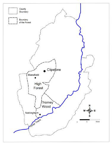
Sherwood Forest was a vast area which from the 13th century stretched from the River Trent in the south to the River Meden in the north and from the Doverbeck in the east to the River Leen in the west.
The Forest was a mixed landscape of villages and towns, as well as woodland and heathland.
It is noticeable that Sherwood forest was more wooded and had larger areas of heathland in the northern section. This area was known as the 'High Forest'. This area seems to have been more remote and would have been the ideal hideout for outlaws and villains!
The area to the south and east was more heavily inhabitted and had more villages and fields and domestic occupation. There were however extensive areas of woodland and heathland in the southern area including 'Bestwood Park'-
A third area known as 'Rumwood' was included in the laws of the forest although it was north of the forest boundary. This is the area around Clumber park.

The Major Oak , 1000 year old veteran oak tree and legendary hide away of Robin Hood

Ancient Heath Land in Sherwood Forest

Ancient Heath Land in Sherwood Forest
Boundaries of the Forest:
In the reign of Henry II (1154-
In fact this area extended into Derbyshire as far as the River Derwent.
All of that combined area of forest was at that time under the control of Maud De Caux as hereditary keeper of the forests of Nottinghamshire and Derbyshire.
This is the period that nowadays we most readily associate with Robin Hood.
This large expansion of forest law under the Angevin kings proved very unpopular.
In 1215 King John was forced to sign the Magna Carta-
Pressure to reduce the extent of the forest led to the inclusion of Forest Clauses in the great charter.
King John was not happy however and he quickly dismissed Magna Carta and went on the attack.
In 1216 King John died at Newark Castle (Nottinghamshire) having lost the crown jewels in the Wash.
Many barons had backed Louis heir to the throne of France-
However the great warrior of the age William Marshal forced the barons to fall in behind Johns 9 year old son, who was crowned Henry III in 1216.
Louis returned to France no longer king of England.
In 1217 a separate Charter of the Forest was created-
The Forest Charter of 1217 aimed at the reduction of the area of land subject to Forest Law.
Between 1218 and 1227 a number of perambulations of the forest boundary took place.
Eventually the boundary of Sherwood Forest was set for the remainder of the medieval period.
The boundary from the 13th century onwards was from the River Trent in the south to the River Meden in the north, and from the Doverbeck and the King's highway (now the A614 roughly see the Road to York entry) in the east to River Leen in the West
Picture: Boundaries post 1300.
Reasons for a Forest in Sherwood:
Sherwood Forest was situated entirely within the county of Nottinghamshire, in the English Midlands.
Almost exactly in the centre of England.
There were many reasons why it was considered an ideal location for a Royal Forest when it was established sometime in the early Norman period.
Some of these are outlined below.
Geology
The area north and west of the Trent was an ideal location for a forest, especially the area of the Sherwood Sandstone geology
These Permo-
This lack of fertility resulted in less arable cultivation of this sandstone region. Domesday book of 1086 show this area to be far lower in arable land use than the corresponding areas of the Mercia Mudstones and the highly fertile area of the Trent valley.
Domesday book shows the whole of the area north and west of the river Trent to be dominated by Wood-
Place name evidence
This landscape of trees, pasture and open heathland can be traced back beyond Domesday and the Norman conquest.
Placename evidence presumed to date from the Dark Ages suggests this area was characteristically well wooded.
The placename ending 'ley' is thought to indicate a clearing in woodland.
The placename field as in 'Ashfield' suggests an area of open heathland.
It is noticeable that all of these are north and west of the river Trent
Crown possessions
As well as the natural state of the land, another crucial reason for choosing Sherwood was that the crown had a significant influence in the area.
The Royal manors of Arnold, Bothamsall, Dunham, and Mansfield (the largest manor in the county in the medieval period) were all north and west of the river Trent.
All these elements combined to make this area an ideal location for a royal hunting forest.
Deer love woodland and heathland-
Focus of the Sherwood Forest Archaeology Project:
The project mainly focuses within the boundaries of Sherwood Forest from the early 12th century and 13th century Forest as shown in the map to the right.
The earliest boundary of Sherwood Forest in the records come from 1156 but refers to the boundaries of the forest in circa 1100.
This area includes all of that highlighted in mid-
This area includes all of the Sherwood Sandstone formation and includes the whole of the Hatfield division of the ancient Wapentake of Bassetlaw (see Battle of Hatfield for more details).
During the time of Henry II (1154-
Following magna Carta (1215) and the subsequent Forest Charter (1217) the area of Forest in Nottinghamshire was reduced to that shown in dark-
The first perambulation defining the boundary of the Forest was in 1218 and subsequent perambulations through the 13th century resulted in the 13th century boundary as depicted on the ma, confirmed by Edward I in the year 1300.
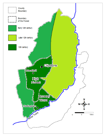
Map: Boundaries of Sherwood Forest © Mercian Archaeological Services CIC, 2018.
Written by Andy Gaunt, Director, Mercian Archaeological Services CIC.
Project page links:
-
-
-
-
-
-
-
-
The Sherwood Forest
National Nature Reserve Archaeology Survey
-
Long term Research at
King John’s Palace:
Ancient Royal Heart of Sherwood Forest
-
The Sherwood Forest Archaeology Training Fieldschool
-
“Scirwuda-
Ghost and Shadow woods of Sherwood Forest Project
-
Investigating Thynghowe Viking
Meeting Site
-
Searching for the
The Battle of Hatfield
-
-
Fieldswork at St Edwin’s Chapel
-
St Mary’s Norton-
-
Mapping Medieval Sherwood Forest
-
The Sherwood Forest LiDAR
Project
-
Warsop Old Hall
Archaeological Project
-
The Sherwood Villages Project:
Settlement Development in the Forest
-
-
-
Researching Edward IIs fortification at Clipstone Peel
-
-
-
-
The Cistercians of Rufford Project:
Settlement Development, Dynamics and Desertion.
-
Sherwood Forest Environmental Survey
-
World War II in Sherwood Forest -
-
World War I in Sherwood Forest -
-
About Medieval Sherwood Forest
-
Robin Hood and Sherwood Forest
-
-
-
-
-
-
-
-
-
-
-
-
Community Archaeology in Derbyshire
Community Archaeology in Leicestershire
Community Archaeology Nottinghamshire, Excavation, Research, Volunteering, Community Archaeology Derbyshire, Training, Social, Learning, Community Archaeology Leicestershire, Heritage, Involvement, Belonging, Knowledge sharing, Community Archaeology Lincolnshire, Topographic Survey, Talks and Presentations, Outreach, Archaeology Projects , Open Days, Schools, Finds Processing, Day Schools, Field Schools, Young People, Archaeology and History of Sherwood Forest, Pottery Research, Medieval, Roman, Prehistoric, Community Interest Company, Community Archaeology Nottinghamshire.
Community Archaeology in Nottinghamshire
Community Archaeology East Midlands
Community Archaeology in Lincolnshire
Community Archaeology in Yorkshire
Mercian Archaeological Services CIC
Specialists in Community Archaeology, Public Involvement, Research & Training
© Mercian Archaeological Services CIC 2024. Registered Business No. 08347842. All Rights Reserved.


The Future of Sherwood’s Past


Community Archaeology Nottinghamshire, Community Archaeology Derbyshire, Community Archaeology Leicestershire, Community Archaeology East Midlands, Mercian Archaeological Services Community Archaeology for Nottinghamshire, Derbyshire, Sherwood Forest, Leicestershire and the East Midlands. Community Archaeology Nottinghamshire, Community Archaeology East Midlands, Community Archaeology Leicestershire. Archaeological
About Medieval Sherwood Forest -