The following is a “Story from the Forest” which aims to bring history to life. The story is a description of a journey from Rufford Abbey to Nottingham in medieval times and follows the route of the ‘Kings Road to York’, or the ‘Kings Highway’, through the world famous Sherwood Forest.
The story is based on a landscape recreated by historic mapping and document research, LiDAR analysis and much more undertaken by Andy Gaunt and Mercian.
The landscape has been built as part of Mercian’s ‘Mapping Sherwood Forest Project’, which is part of the Sherwood Forest Archaeology Project, and is based on years of research into the landscape of Sherwood Forest.
The aim of the Sherwood Forest Archaeology Project overall is not simply to investigate and to recreate past landscapes, but also to bring them to life through story-
We hope you enjoy the journey…
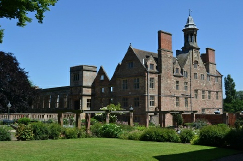
Picture: Rufford Abbey, Nottinghamshire.
Rufford Abbey was a monastery of Cistercian monks in the heart of medieval Sherwood Forest.
It was situated in the high forest area to the south of the village of Ollerton, and to the west of the Royal Palace and Deer Park of Clipstone.
Nestled amongst it's domestic buildings and accommodation, the church of St. Mary the Virgin would have been a glorious landmark, standing in the heathland of the high forest.
The abbey would have been a welcome sight to the traveller passing through the forest.
A traveller heading south from York might have spent the previous night in the inland medieval port town of Bawtry on the Yorkshire border, or maybe in the castle town of Tickhill, or at the monastery in Blyth.
The Idle marshes would have been negotiated along with the heather-
Having found accommodation in the Abbey at Rufford-
Restful that is, if they could sleep through the chanting, bell-

The life of the medieval monk didn't seem to involve much sleeping.
Sleeping on a straw-
It was part of the duty of medieval monks to provide accommodation and food to travellers (of course the level of comfort depended on wealth-
The poor might receive the left-

Picture: The Undercroft at Rufford Abbey, Sherwood Forest, Nottinghamshire.
Having woken, eaten, and departed, the traveller would head east to meet the road to Nottingham.
The trackway from the monastery might have been shared by some of the Cistercian 'Lay Brothers' heading to till the fields of Cratley (a village taken over by the abbey in the 12th century) to the east.
Cistercian monks were not permitted to work-
The meadows of the abbey covered the shallow valley of Rainworth water to the south of the road, and the woods of 'Welley (Wellow) Beskall' and 'In Beskall' hugged the north side of the road and extended into the distance.
On reaching the Kings Highway the road was rejoined and the journey south continued following the higher ground of the Mercia Mudstones ridge overlooking the meadows of the abbey which lay on the western side. These meadows would provide fodder for the abbey's animals, and may have had the occasional Lay Brother tending flocks in the months when grazing was permitted.
Having crossed Rainworth Water at the 'Derun Forthe' (ford); the road began to cross the heathland of the lands of the Lordship of Rufford-
After a walk of some three and a half miles southwards along the Kings Highway towards Nottingham, the traveller came upon a cross-
Here the road from the Kings Manor of Mansfield in the west to the Archbishop of York's great manor and collegiate church at Southwell in the east-
This was known as the Southwell Road.
Heathland dominated the area between Rufford Abbey and the Southwell road and was up to 2 miles across.
Just before reaching the Southwell road the Abbey's wood known as the 'Burne Abotote wode' (the brown wood of the Abbot) and the wood of 'Leytle Hawe' appeared on the western side.
While to the east the lands of the village of Farnsfield stretching down the valley of the River Greet. The River Greet flowed eventually through the aforementioned town of Southwell, before winding its way into the River Trent many miles away.
The Abbot of Rufford’s woods, gave way to another wood called 'ye Byshope wode' (the wood of the Archbishop of York that joined on to it on its southern edge).
It would not be wise to be caught damaging or stealing anything in either of these woods as, as well as having to deal with the Forest Law, any would-
The punishment there could also include eternal damnation.
These woods were of such a size, that they stretched along the roadside for a full 2 miles, as the traveller passed by.
This area of woodlands was also 2 miles wide and could easily have sheltered many outlaws in its shadowy depths.
The traveller would be well advised to stick to the road.
As it was little time could be spared to explore these deep woods-
As well as the previously mentioned ‘ye Bishope Wode’, these woods were divided into other compartments known by the names:
'Blidworth Wood', 'Lerche Haw', 'Balkhaw', 'Seyre Birkes' and 'Hay Wode'.
Haywood Oaks is still a popular destination today with many veteran oak trees in its woodland.
Continuing over the undulating Sherwood Sandstones the road crossed the Doverbeck River, a diminutive sandstone stream which none-
From this point; and the road continued south over Salterford Waste, a large expanse of wood-
This area of grazing merged seamlessly into the lands of the village of Calverton, where it became known as ‘Calverton Common’.
To the traveller the difference between ‘Salterford Waste’ and ‘Calverton Common’ may have been unnoticeable, but to the villagers who lived in this land, such land divisions were very important and were heavily guarded.
Rights to pasture were very important to life in the medieval Forest.
The great Common of Calverton village stretched away to the southeast and the King's Highway passed into and through a small area of woodland known as 'Samson Wode' (A plantation of pines now carries the name).
Upon leaving the shadowy bows of Samson Wode the road now headed across the heather clad 'Arhall (Arnold) Common' which stretched for nearly 3 miles to the south; here again great herds of swine and sheep grazed on the land, tended by shepherds and swineherds.
After crossing this great heathland two roads converged with the King's Highway-
They met at a standing cross on the road known as 'Xpian Cross'. The road from here then climbed steeply to pass through a deep holloway cut by traffic and footfall through the Mercia Mudstones.
This cutting exposed red clay deposits of the Mercia Mudstones and Sneinton Shale deposits, and was therefore known as 'ye rede (red) royde (road) hil' (The ridge is still known as 'Redhill' to this day).
Nowadays this cutting marks the entry into the 'Greater Nottingham Conurbation' from the surrounding countryside; and in medieval times it would have also been a mark of having left the great wilderness of the 'High Forest' region of Sherwood.
The traveller was now entering the gentler 'Thorney Wood' area of the forest.
The King's manor of Arnold nestled to the east of the road beneath the surrounding highland, where the woods of 'Arnold Common Wood', 'Swine Howse' and 'Basforde wode' occupied the clay ridge.
To the west the road was now overlookd by the 3 metre high deer fence of the Royal Park of Bestwood.
The arable field of Arnold to the side of Bestwood park was known as 'Parke Field' and this was crossed by the road from north to south.
At its southern end the road forded the Depe Broke (modern Daybrook).
The road then crossed the 'South field' of Arnold before climbing the ridge of sandstone known as 'Brymisdale Knoll' in medieval times, and descending into 'Brymmsdale' to the south.
This area was 'Basforde Lyngges' another vast expanse of heather clad heathland, dotted with wood-
Ling was the Old Scandinavian name for heather, so we can picture how this area may have looked from its name.
This common pasture land was crossed for two miles, but stretched for three miles wide; as far as the eye could see.
It would have been grazed by the flocks of Basforde but also by those of Nottingham.
Having crossed the heath from the north-
After nearly 15 miles on uneven and un-
Here accommodation and ale could be found a-
If the Saturday market was being held-
The traveller had made it across the forest, hopefully with time to find a bed and a table at an alehouse or inn, to exchange stories around the fire place with other travellers, and to prepare plans for the journey across the arduous Midland Clays on the London road to the south.
For now though at least, legendary Sherwood Forest had been safely navigated.
Enjoyed the journey?
Why not try to follow the route on the modern map?
The map above is set to centre on Rufford Abbey. Nottingham is to the south.
The first part of the journey is sadly not possible as the road has moved to the west from its original line. Although we have a good idea where it ran, it would be too difficult to explain here, except that it ran to the western side of the Village of Wellow, east of Rufford Abbey.
However, if you move south from Rufford, when you get west of the village of Bilsthorpe you can follow what is shown as “Old Rufford Road” -
Look out for features such as Baulker Lane, Haywood Oaks, the villages of Farnsfield and Calverton… these are clues to the medieval landscape still present in the names today.
Follow this road until it becomes the A60 and heads south into Nottingham.
The modern conurbation is far larger than the medieval town, but as you journey south look out for Arnold Town, Red Hill, Bestwood, Daybrook, Forest Fields… again, these are clues to the medieval landscape still present in the names today.
When you get into the centre of Nottingham look for INTU Victoria Centre. To the south of this runs Parliament Street (running east-
This street was where the town wall ran on the north side. The toown was entered via the ‘Cow Gate’ on the junction with Milton Street and Parliament Street.
The Medieval market was held in ‘Old Market Square’.
Medieval Nottingham was confined to the area between the Ice Arena in the east, and Nottingham Castle in the West.
The site of the Castle is shown.
On the southern side the town limits reached as far as roughly the INTU Broadmarsh shopping centre under which are some of the best-
If you zoom out you can see the area to the south known as ‘The Meadows’ (no prize for guessing what this area was used for in medieval times) stretching down to the River Trent.
(Andy Gaunt, updated 21/04/2020)
Based on on-
Click here for more ‘Stories from the Forest’…


Community Archaeology Nottinghamshire, Community Archaeology Derbyshire, Community Archaeology Leicestershire, Community Archaeology East Midlands, Mercian Archaeological Services Community Archaeology for Nottinghamshire, Derbyshire, Sherwood Forest, Leicestershire and the East Midlands. Community Archaeology Nottinghamshire, Community Archaeology East Midlands, Community Archaeology Leicestershire. Archaeological

A Journey through Sherwood Forest: Rufford Abbey to Nottingham
Award Winners 2016
for "Engaging people in the heritage, history & archaeology of Sherwood Forest".


Some funders and partners:
World-


Mercian Archaeological Services CIC
Specialists in Community Archaeology, Public Involvement, Research & Training
Community Archaeology Nottinghamshire, Excavation, Research, Volunteering, Community Archaeology Derbyshire, Training, Social, Learning, Community Archaeology Leicestershire, Heritage, Involvement, Belonging, Knowledge sharing, Community Archaeology Lincolnshire, Topographic Survey, Talks and Presentations, Outreach, Archaeology Projects , Open Days, Schools, Finds Processing, Day Schools, Field Schools, Young People, Archaeology and History of Sherwood Forest, Pottery Research, Medieval, Roman, Prehistoric, Community Interest Company, Community Archaeology Nottinghamshire.
Community Archaeology in Nottinghamshire
Community Archaeology in Derbyshire
Community Archaeology in Leicestershire
Community Archaeology East Midlands
Community Archaeology in Lincolnshire
© Mercian Archaeological Services CIC 2013. Registered Business No. 08347842. All Rights Reserved.
The Future of Sherwood’s Past
Project page links:
-
-
-
-
-
-
-
-
The Sherwood Forest
National Nature Reserve Archaeology Survey
-
Long term Research at
King John’s Palace:
Ancient Royal Heart of Sherwood Forest
-
The Sherwood Forest Archaeology Training Fieldschool
-
“Scirwuda-
Ghost and Shadow woods of Sherwood Forest Project
-
Investigating Thynghowe Viking
Meeting Site
-
Searching for the
The Battle of Hatfield
-
-
Fieldswork at St Edwin’s Chapel
-
St Mary’s Norton-
-
Mapping Medieval Sherwood Forest
-
The Sherwood Forest LiDAR
Project
-
Warsop Old Hall
Archaeological Project
-
The Sherwood Villages Project:
Settlement Development in the Forest
-
-
-
Researching Edward IIs fortification at Clipstone Peel
-
-
-
-
The Cistercians of Rufford Project:
Settlement Development, Dynamics and Desertion.
-
Sherwood Forest Environmental Survey
-
World War II in Sherwood Forest -
-
World War I in Sherwood Forest -
-
About Medieval Sherwood Forest
-
Robin Hood and Sherwood Forest
-
-
-
-
-
-
-
-
-
-
-
-