


Community Archaeology Nottinghamshire, Community Archaeology Derbyshire, Community Archaeology Leicestershire, Community Archaeology East Midlands, Mercian Archaeological Services Community Archaeology for Nottinghamshire, Derbyshire, Sherwood Forest, Leicestershire and the East Midlands. Community Archaeology Nottinghamshire, Community Archaeology East Midlands, Community Archaeology Leicestershire. Archaeological

The Oldest Known Boundary of Medieval Sherwood Forest
Award Winners 2016
for "Engaging people in the heritage, history & archaeology of Sherwood Forest".


Some funders and partners:
World-


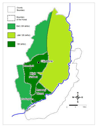
The Oldest known boundary
The oldest known boundary for Sherwood Forest-
This inquest was held in 1155/6 (see Crook 1994 in bilbliography).
This was at the start of the reign of Henry II.
Henry II was the grandson of Henry I.
Henry I was king from 1100-
She was married to his main rival Geoffrey Planaganet the Duke of Anjou.
The Norman barons feared having the Duke of Anjou on the throne and instead invited Stephen of Blois a Norman lord and nephew of Henry I who became King Stephen of England in 1135.
Matilda and Geoffrey fought back and a civil war known as the 'Anarchy' enveloped England for nearly 20 years.
The ultimate result was that Stephen accepted Matilda and Geoffrey's son Henry of Anjou as his successor.
Henry became king of England as Henry II in 1154 (reigning until 1189)
He set about restoring his kingdom to how it had been in the reign of his grandfather Henry I.
In Nottinghamshire he held the inquest mentioned above to determine the extent of the forest and the Archbishops rights against it in the reign of his grandfather.
This boundary covered the western half of the county extending from the Trent in the south up the Doverbeck river in the southeast to where it crossed the Kings Highway to York.
It then followed this road to the boundary of the county at Bicarrs Dyke in the far north.
Everything to the west of this line was called the 'old forest in the time of Henry I (1100-
This is interesting in that this area is significantly larger than that defined as Sherwood Forest in the 13th century (see boudaries page).
This boundary includes the area to the north known as 'Hatfield' meaning heath field-
Does this mean the original forest followed this boundary?
Mercian Archaeological Services CIC
Specialists in Community Archaeology, Public Involvement, Research & Training
Community Archaeology Nottinghamshire, Excavation, Research, Volunteering, Community Archaeology Derbyshire, Training, Social, Learning, Community Archaeology Leicestershire, Heritage, Involvement, Belonging, Knowledge sharing, Community Archaeology Lincolnshire, Topographic Survey, Talks and Presentations, Outreach, Archaeology Projects , Open Days, Schools, Finds Processing, Day Schools, Field Schools, Young People, Archaeology and History of Sherwood Forest, Pottery Research, Medieval, Roman, Prehistoric, Community Interest Company, Community Archaeology Nottinghamshire.
Community Archaeology in Nottinghamshire
Community Archaeology in Derbyshire
Community Archaeology in Leicestershire
Community Archaeology East Midlands
Community Archaeology in Lincolnshire
© Mercian Archaeological Services CIC 2013. Registered Business No. 08347842. All Rights Reserved.
The Future of Sherwood’s Past
Project page links:
-
-
-
-
-
-
-
-
The Sherwood Forest
National Nature Reserve Archaeology Survey
-
Long term Research at
King John’s Palace:
Ancient Royal Heart of Sherwood Forest
-
The Sherwood Forest Archaeology Training Fieldschool
-
“Scirwuda-
Ghost and Shadow woods of Sherwood Forest Project
-
Investigating Thynghowe Viking
Meeting Site
-
Searching for the
The Battle of Hatfield
-
-
Fieldswork at St Edwin’s Chapel
-
St Mary’s Norton-
-
Mapping Medieval Sherwood Forest
-
The Sherwood Forest LiDAR
Project
-
Warsop Old Hall
Archaeological Project
-
The Sherwood Villages Project:
Settlement Development in the Forest
-
-
-
Researching Edward IIs fortification at Clipstone Peel
-
-
-
-
The Cistercians of Rufford Project:
Settlement Development, Dynamics and Desertion.
-
Sherwood Forest Environmental Survey
-
World War II in Sherwood Forest -
-
World War I in Sherwood Forest -
-
About Medieval Sherwood Forest
-
Robin Hood and Sherwood Forest
-
-
-
-
-
-
-
-
-
-
-
-