


Community Archaeology Nottinghamshire, Community Archaeology Derbyshire, Community Archaeology Leicestershire, Community Archaeology East Midlands, Mercian Archaeological Services Community Archaeology for Nottinghamshire, Derbyshire, Sherwood Forest, Leicestershire and the East Midlands. Community Archaeology Nottinghamshire, Community Archaeology East Midlands, Community Archaeology Leicestershire. Archaeological

Medieval Nottingham
Award Winners 2016
for "Engaging people in the heritage, history & archaeology of Sherwood Forest".


Some funders and partners:
World-


Mercian Archaeological Services CIC
Specialists in Community Archaeology, Public Involvement, Research & Training
Community Archaeology Nottinghamshire, Excavation, Research, Volunteering, Community Archaeology Derbyshire, Training, Social, Learning, Community Archaeology Leicestershire, Heritage, Involvement, Belonging, Knowledge sharing, Community Archaeology Lincolnshire, Topographic Survey, Talks and Presentations, Outreach, Archaeology Projects , Open Days, Schools, Finds Processing, Day Schools, Field Schools, Young People, Archaeology and History of Sherwood Forest, Pottery Research, Medieval, Roman, Prehistoric, Community Interest Company, Community Archaeology Nottinghamshire.
Community Archaeology in Nottinghamshire
Community Archaeology in Derbyshire
Community Archaeology in Leicestershire
Community Archaeology East Midlands
Community Archaeology in Lincolnshire
© Mercian Archaeological Services CIC 2013. Registered Business No. 08347842. All Rights Reserved.
The old medieval town of Nottingham was entirely surrounded by Sherwood Forest.
It was in fact within the forest, but seems to have been exempt from the forest laws within its walls and out across its great open fields.
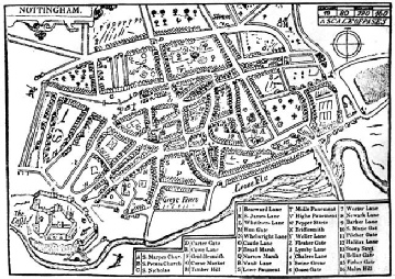
Picture: John Speeds map of Nottingham 1610
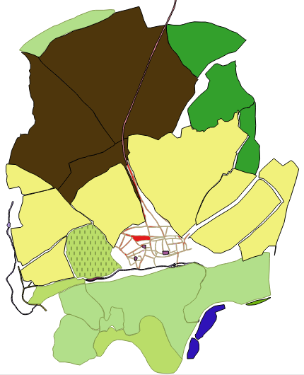
Picture: Medieval Nottingham. Extract from the data-
©Mercian Archaeological Services CIC 2018.
The town was nestled on top of a natural rise in the Sherwood Sandstones, overlooking the Trent Valley to the south.
The Medieval town stretched from the ‘broadmarsh’ in the south to current day Parliament Street in the north (this street was originally called ‘backside’ – which caused great merriment in the 19th century when appalling sanitary conditions in the overcrowded Victorian town led the local MP to petition parliament to have his “backside cleaned”.
At the north side was the town wall accessed through the 'cow bar' gate along the Kings road to York.
Beyond this gate were the two great arable fields of the town, the Lingdale field (later called the sand field after the soils formed from the underlying geology) and the Wood field (named after its proximity to the great wood of the town which was adjacent to it to the north east. Renamed the Clay field by the 17th century-
At the top of the hill (at current day junction with Forest Road) stood the town Gallows-
Beyond the gallows stretched the vast heather clad Basford Waste, stretching as far as the open fields of Arnold some miles to the north. This open heathland was used by the town to graze pigs and sheep and other livestock. Beyond the waste was the great Royal deer park of Bestwood with its tall wooden fence or pale and its hunting lodge visible on top of a large hill.
To the south the great meadows of the town stretched down to the banks of the Trent. These are reported as being awash with purple crocuses in the 18th century and must have been beautiful at certain times of the year.
The people of the town had the right to graze animals on the meadows in certain seasons.
The town bull was also kept here.
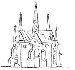
Picture: Lentun Habay (Lenton Abbey, Lenton Priory) redrawn by Andy Gaunt from the Belvoir map a late 14th-
To the west, beyond the oaks and lawns of the castle deer park stood Lenton Priory, visible across the meadows from the River Trent to the south; along with St. Mary’s Church in the English town and the churches of St. Peter and St Nicholas in the French quarter, spiritual guardians of the town. The priory was the greatest stone building in the town.
When it was built even the castle itself was still of wooden construction.
To the east stood the village of Sneinton; nestled on a sandstone bluff above the floodplain, with it’s hermitage of caves; shrines and dwellings of religious men.
The River Leen flowed eastwards past the foot of castle rock, diverted there to allow access from the Trent to the castle by William Peverel (see Medieval Nottingham Castle and the Honour of Peverel entries for more info). Wharves cluttered the area beneath the rock, where goods were loaded and unloaded for the castle. The Leen then headed south across the meadows towards the river Trent.
The River Trent was crossed by the road to London over the Trent Bridge known at the time as the Hethbeth Bridge.
This bridge was often in need of repair and must have been a wonder to behold with its chantry chapel and all the hustle and bustle of medieval life along its length.
Some remains of the medieval stone bridge are still visible to the south of the current bridge.
The river Trent must have been full of boats with large sales unloading and loading coal, wool, food, ale and luxuries such as spices which formed the economy of the town.
These were all traded either at the daily market at weekday cross in the old English quarter or in the Saturday market in the towns market square.
Nottingham was divided into two parts during the medieval period. The original English town (now the lace market area) and the ‘new’ or ‘French’ town which developed as streets radiating out from the Norman castle built by William Peveril in 1067 to the west of the town.
Between the two sides was the market square which would become the heart of the town over the following centuries.
This town and the landscape of Sherwood Forest form the backdrop to the stories and life of the age
The Future of Sherwood’s Past
Project page links:
-
-
-
-
-
-
-
-
The Sherwood Forest
National Nature Reserve Archaeology Survey
-
Long term Research at
King John’s Palace:
Ancient Royal Heart of Sherwood Forest
-
The Sherwood Forest Archaeology Training Fieldschool
-
“Scirwuda-
Ghost and Shadow woods of Sherwood Forest Project
-
Investigating Thynghowe Viking
Meeting Site
-
Searching for the
The Battle of Hatfield
-
-
Fieldswork at St Edwin’s Chapel
-
St Mary’s Norton-
-
Mapping Medieval Sherwood Forest
-
The Sherwood Forest LiDAR
Project
-
Warsop Old Hall
Archaeological Project
-
The Sherwood Villages Project:
Settlement Development in the Forest
-
-
-
Researching Edward IIs fortification at Clipstone Peel
-
-
-
-
The Cistercians of Rufford Project:
Settlement Development, Dynamics and Desertion.
-
Sherwood Forest Environmental Survey
-
World War II in Sherwood Forest -
-
World War I in Sherwood Forest -
-
About Medieval Sherwood Forest
-
Robin Hood and Sherwood Forest
-
-
-
-
-
-
-
-
-
-
-
-