Medieval Sherwood Forest was not one giant wood, but had a mixed landscape of villages with their arable fields, pasture and meadows. The forest however was chosen because it had a large amount of woodland and heath.
There were many different woodlands across the forest,including wood-
A huge area of woodland stretched north-
In the northern High forest there were also many woods such as the mighty Mansfield Wood, Kirkby wood, Haywood Oaks, and the woods of Clipstone and Edwinstowe.
The crown also held the two great woodlands of Birklands and Bilhaugh (now the Sherwood Forest National nature Reserve).
Alongside all of these was a wood described in the Sherwood Forest Books as the ‘chief wood of Sherwood’; named Lyndhurst Wood (spelt Lindhurst in modern times).
Lyndhurst means ‘lime-
In the medieval period however it was predominantly Oak-
It probably originated as a large area of wood-
Historian David Crook published a paper on the history of the wood, and listed the following:
‘During the extensive works that took place at the castle between 1358 and 1368, when Stephen Romylowe was constable, a great deal of timber was taken from Lindhurst. The surviving accounts give details of the employment of carpenters and sawyers there and of the expenses of carting the timber to Nottingham.’ (Crook 1981 in bibliography).
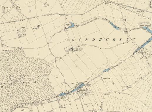
Picture: Ordnance Survey 6 inches to 1 mile map published 1883/5. The area recognised as Lindhurst at that time (likely not extending as far west as in medieval times) can be seen with the water-
Lyndhurst was originally all the 'wode growing on the eesh parte (east part) of the grete (great) way that leedeth betwxyt Notynhham (Nottingham), and Maunsfeild (Mansfield) unto Sothwell rode (Southwell road) in lengith (length), and the syke (stream) of Rayewath (Rainworth Water) on the southe parte, and the valey where a syke called oulde Idle (foulevil brook) hathe the course of the northe parte in lengith, is called the chieffe wode of the foresh of Shirewood (the chief Wood of Sherwood Forest)'
As stated above the wood was defined by Rainworth Water (a tributary of the River Maun) to the south, and on its northeastern side by a stream called ‘foulevil brook’ (a tributary of Rainworth Water)-
The name is preserved on Sanderson’s 1835 map of 20 miles around Mansfield, but the stream is not shown with this name on the 1885 map above.
The Wood was positioned to the south of the manor of Mansfield and to the north of the manor of Blidworth. The Manor of Mansfield belonged to the Crown, and Blidworth belonged to the Archbishop of York.
Lyndhurst was a jealously guarded property of the crown and was separate to the Manor of Mansfield.
It had its own keeper: in the 13th and early 14th century its keeper was Ralph Clere who lived in a lodge called the ‘new repair’ on its southern side.
This site may have been positioned within a moat. The remains of a moated site still survive to this day and can be seen on the map below.
This keeper of Lyndhurst as well as looking after the wood had the job of collecting the tax of Cheminage, a toll on carts passing through the forest, payable to his master the Keeper of Sherwood Forest Robert D'Everingham.
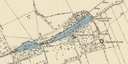
Picture: Ordnance Survey 6 inches to 1 mile map of 1885. The map shows a set of fish ponds with a ‘Moat’ depicted on the eastern pond’s northern bank. ‘Friar Tuck’s Well’ is located towards the eastern end of the larger pond.
This moated site, former home of the keeper of Lyndhurst Wood, was located in a shallow valley named Fountain Dale.
This is where history and legend merge.
The moated site in Fountain Dale is sometimes called ‘Friar Tuck’s Island’.
It is accompanied by a spring on the opposite side of Rainworth Water, known as ‘Friar Tuck's Well’.
The link of friar Tuck to the site, seems to have emerged from one of the medieval ballads of Robin Hood.
“Robin Hood and the Curtal Friar” is a ballad believed to date from the late medieval period.
The synopsis of the ballad is that Robin Hood’s outlaw band enjoy a successful hunt. Little John kills a Hart (a male Red Deer) from 500 yards away with an arrow.
Robin Hood claims that within a hundred miles there is no match for Little John.
Will Scadlock (Scarlett) tells him a certain friar is a match, and Robin Hood sets of to find him.
He meets the friar at a river Robin forces the friar to carry him across, but on doing so the friar throws him in the water half way.
They battle.
Eventually Robin asks to be allowed to blow his horn. The Friar agrees and the Merry Men arrive, armed with bows.
The friar asks a favour to be allowed to blow a whistle-
After a stand-

Picture: The friar took Robin on his back by Louis Rhead 1912. Attribution:Louis Rhead / Public domain. https://commons.wikimedia.org/wiki/File:The_friar_took_Robin_on_his_back_by_Louis_Rhead_1912.png
The following line from the ballad mentions a site by the name of Fountain Dale:
“This curtal frier had kept Fountains Dale
Seven long years or more;
There was neither knight, lord, nor earl
Could make him yield before.”
(https://d.lib.rochester.edu/teams/text/robin-
This version of the ballad also refers to the Friar being at Fountain’s Abbey in Yorkshire, and this could represent an early struggle between Sherwood Forest in Nottinghamshire, and the county of Yorkshire for ownership of the legends.
Other versions also mention a Fountain Dale:
“Robin Hood put on his harness good,
And on his head a cap of steel,
Broad sword and buckler by his side,
And they became him weel.
He took his bow into his hand,
It was made of a trusty tree,
With a sheaf of arrows at his belt,
To the Fountains Dale went he.
And comming unto Fountain[s] Dale,
No further would he ride;
There was he aware of a curtal frier,
Walking by the water-
The fryer had on a harniss good,
And on his head a cap of steel,
Broad sword and buckler by his side,
And they became him weel.
Robin Hood lighted off his horse,
And tied him to a thorn:
‘Carry me over the water, thou curtal frier,
Or else thy life’s forlorn.’”
(sacred-
Robin Hood and the Curtal Friar then fought for many an hour… eventually the Friar joins Robin Hood’s gang, as stated above.
Whether this ‘curtal friar’ can be linked to Friar Tuck has been much debated by historians, and whether or not this ‘Fountain Dale’ was in Yorkshire or Nottinghamshire, is also open to debate.
However one thing that is clear is that the association of Robin Hood and Friar Tuck to Fountain Dale in Nottinghamshire was sufficiently well established in the early 19th century to make it a place to visit for tourists coming from as far afield as the United States of America.
The site of Fountain Dale was visited by no less than the American author Washington Irving (author of ‘Rip van Winkle’ (1819) and ‘The Legend of Sleepy Hollow’ (1820)), in 1817.
Irving had travelled to stay with his friend Walter Scott at his home of Abottsford in that year. In 1820 Scott would publish his novel Ivanhoe; the medieval epic which helped to catapult Robin Hood to international celebrity status.
After saying at Abottsford, he travelled to Newstead Abbey, the former home of the Romantic poet Lord Byron, in Sherwood Forest, as a pilgrimage to the home of the poet, and also in search of Robin Hood.
Lord Byron was no longer resident, and so Irving stayed with the current owner of Newstead, Thomas Wildman.
The two spent much time exploring the landscape of Sherwood Forest. The following is Irving’s description of a tour to Fountain Dale moated site:
“A little farther on, and we were again on the traces of Robin Hood. Here was Fountain Dale, where he had an encounter with that stalwart shaveling Friar Tuck, who was a kind of saint militant, alternately wearing the casque and the cowl:
“The Cutral fryar kept Fountain dale
Seven long years and more,
There was neither lord, knight or earl
Could make him yield before.”
The moat is still shown which is said to have surrounded the stronghold of this jovial and fighting friar; and the place where he and Robin Hood had their sturdy trial of strength and prowess, in the memorable conflict which lasted
“From ten o’clock that very day
Until four in the afternoon,”
and ended in the treaty of fellowship. As the hardy feats, both of sword and trencher, performed by this “curtal fryar,” behold are they not recorded at length in the ancient ballads, and in the magic pages of Ivanhoe?”
[*note Irving did not publish his account of the trip until years after, by which time Ivanhoe had been published by Scott in 1820. Walter Scott is himself believed to have written parts of Ivanoe while staying at Fountain Dale Lodge.]
…”The evening was fast coming on, and the twilight thickening, as we rode through these haunts famous in outlawry. A melancholy seemed to gather over the landscape as we proceeded, for our course lay by shadowy woods, and across naked heaths, and along lonely roads, marked by some of those sinister names by which the country people in England are apt to make dreary places still more dreary. The horrors of “Thieves’ Wood”, and the “Murderers’ Stone”, and “the Hagg Nook” had all to be encountered [see the map below] in the gathering gloom of evening, and threatened to beset our path with more than mortal peril. Happily, however, we passed these ominous places unharmed, and arrived in safety at the portal of Newstead Abbey, highly satisfied with our green-
(From Abbotsford and Newstead Abbey, by Washinton Irving)
This wonderful account of a journey through the forest brings the landscape to life, and also helps us to push the link of Friar Tuck back slightly further than historic mapping allows us: the name ‘Fountain Dale’ is only known from the early 19th century (1835) on historic mapping, however Irving’s visit in 1817 clearly relates to a well established link pre-
Perhaps the legendary link is older than we know…
Hopefully this “Story from the Forest” has shown how in Sherwood Forest the ancient sites of the medieval Forest have a rich archaeological and historical story to tell in their own right.
Hopefully it has also shown that the landscape is a rich tapestry of archaeology, history, and heritage, and also legend and folklore, woven with elements from medieval ballads and tales, and by later poets and writers, who were themselves stirred by imaginings of Robin Hood, and who through their story-
It is our aim at Mercian through the Sherwood Forest Archaeology Project, that we can contribute just a little to this enrichment, through our own investigations into the archaeology, history and legends.
And to pass this on to others to others through re-
Why not have a look at the map below and ‘zoom in and out’ to see the landscape today; Lyndhurst (modern Lindhurst), Friar Tucks Well and the moated site, The “murderers stone” also known as the “Shepherd Stone” after Bess Sherpherd who was murdered on the spot in 181, and the nearby “Thieves Wood”, “Hagg Nook” and Newstead Abbey.
(Andy Gaunt, first published 05/08/2012, updated 22/04/2020)
Click here for more ‘Stories from the Forest’…
You can find out more about Friar Tuck’s Well here: https://insearchofholywellsandhealingsprings.com/2014/04/08/friar-


Community Archaeology Nottinghamshire, Community Archaeology Derbyshire, Community Archaeology Leicestershire, Community Archaeology East Midlands, Mercian Archaeological Services Community Archaeology for Nottinghamshire, Derbyshire, Sherwood Forest, Leicestershire and the East Midlands. Community Archaeology Nottinghamshire, Community Archaeology East Midlands, Community Archaeology Leicestershire. Archaeological

Lyndhurst -
Award Winners 2016
for "Engaging people in the heritage, history & archaeology of Sherwood Forest".


Some funders and partners:
World-


The Future of Sherwood’s Past
Project page links:
-
-
-
-
-
-
-
-
The Sherwood Forest
National Nature Reserve Archaeology Survey
-
Long term Research at
King John’s Palace:
Ancient Royal Heart of Sherwood Forest
-
The Sherwood Forest Archaeology Training Fieldschool
-
“Scirwuda-
Ghost and Shadow woods of Sherwood Forest Project
-
Investigating Thynghowe Viking
Meeting Site
-
Searching for the
The Battle of Hatfield
-
-
Fieldswork at St Edwin’s Chapel
-
St Mary’s Norton-
-
Mapping Medieval Sherwood Forest
-
The Sherwood Forest LiDAR
Project
-
Warsop Old Hall
Archaeological Project
-
The Sherwood Villages Project:
Settlement Development in the Forest
-
-
-
Researching Edward IIs fortification at Clipstone Peel
-
-
-
-
The Cistercians of Rufford Project:
Settlement Development, Dynamics and Desertion.
-
Sherwood Forest Environmental Survey
-
World War II in Sherwood Forest -
-
World War I in Sherwood Forest -
-
About Medieval Sherwood Forest
-
Robin Hood and Sherwood Forest
-
-
-
-
-
-
-
-
-
-
-
-
Mercian Archaeological Services CIC (Community Interest Company)
An Independent Research Company, specialising in Training, Community Archaeology & Public Involvement.
Community Archaeology Nottinghamshire, Excavation, Research, Volunteering, Community Archaeology Derbyshire, Training, Social, Learning, Community Archaeology Leicestershire, Heritage, Involvement, Belonging, Knowledge sharing, Community Archaeology Lincolnshire, Topographic Survey, Talks and Presentations, Outreach, Archaeology Projects , Open Days, Schools, Finds Processing, Day Schools, Field Schools, Young People, Archaeology and History of Sherwood Forest, Pottery Research, Medieval, Roman, Prehistoric, Community Interest Company, Community Archaeology Nottinghamshire.
Community Archaeology in Nottinghamshire
Community Archaeology in Derbyshire
Community Archaeology in Leicestershire
Community Archaeology East Midlands
Community Archaeology in Lincolnshire
© Mercian Archaeological Services CIC 2019. Registered Business No. 08347842. All Rights Reserved.
Community Archaeology in Yorkshire
Project page links:
-
-
-
-
-
-
-
-
The Sherwood Forest
National Nature Reserve Archaeology Survey
-
Long term Research at
King John’s Palace:
Ancient Royal Heart of Sherwood Forest
-
The Sherwood Forest Archaeology Training Fieldschool
-
“Scirwuda-
Ghost and Shadow woods of Sherwood Forest Project
-
Investigating Thynghowe Viking
Meeting Site
-
Searching for the
The Battle of Hatfield
-
-
Fieldswork at St Edwin’s Chapel
-
St Mary’s Norton-
-
Mapping Medieval Sherwood Forest
-
The Sherwood Forest LiDAR
Project
-
Warsop Old Hall
Archaeological Project
-
The Sherwood Villages Project:
Settlement Development in the Forest
-
-
-
Researching Edward IIs fortification at Clipstone Peel
-
-
-
-
The Cistercians of Rufford Project:
Settlement Development, Dynamics and Desertion.
-
Sherwood Forest Environmental Survey
-
World War II in Sherwood Forest -
-
World War I in Sherwood Forest -
-
About Medieval Sherwood Forest
-
Robin Hood and Sherwood Forest
-
-
-
-
-
-
-
-
-
-
-
-