


Community Archaeology Nottinghamshire, Community Archaeology Derbyshire, Community Archaeology Leicestershire, Community Archaeology East Midlands, Mercian Archaeological Services Community Archaeology for Nottinghamshire, Derbyshire, Sherwood Forest, Leicestershire and the East Midlands. Community Archaeology Nottinghamshire, Community Archaeology East Midlands, Community Archaeology Leicestershire. Archaeological

The oulde course of the Trente at Shelforde
Award Winners 2016
for "Engaging people in the heritage, history & archaeology of Sherwood Forest".


Some funders and partners:
World-


Sherwood Forest was an area of land chosen by the King to be a Royal Forest. A Forest was a designated area -
Forest Law protected the beasts of the chase, giving the king and those with special privileges the exclusive right to hunt within the area.
It was therefore illegal to hunt deer in a Forest without the Kings permission.
It was also illegal to chop down trees for timber. Originally this was to protect the habitat of the deer.
This ‘legal Forest’ had a defined area.
The area was chosen because it contained within it a ‘physical forest’ of woodland, wood-
But it is important to understand the difference. The ‘physical forest’ was a myriad of different woods and open spaces wood-
We generally refer to the ‘legal Forest’ with a capital ‘F’ and the ‘physical forest’ with a lower case ‘f’.
Hence the name Sherwood Forest refers to the legal entity.
Sherwood Forests boundary changed over time; dependant on politics -
The boundary of Sherwood Forest was perambulated (walked -
Some of these perambulations have survived with the earliest perambulation dating to 1218, but other descriptions dating back to circa 1100.
In all of these the boundaries mainly consist of roads and rivers, as these are features which have in general a clear presence, which is fairly permanent, and at least easy to convey to those intending to break the Law.
In all surviving references to the Forests in Nottinghamshire, the southern boundary was the River Trent.
The River Trent passes from west to east, skirting to the south of the medieval town of Nottingham. Nottingham was strategically positioned on a crossing of this river, and grew on a sandstone bluff over-
The 1609 Crown Survey Map of Sherwood Forest shows the southern boundary of Sherwood Forest as it was in the Medieval Period.
It also shows us that rivers are dynamic landscape features, and do not always maintain the same course.
This can be a problem for those who wish to base legal jurisdiction over an area of land, and define it based on the position of that river.
This map shows us that Sherwood Forest extended south all the way to the River Trent.
However at the small village of Shelford it actually crossed the river.
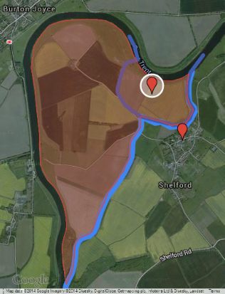
Shelford is a small village lying about 6 miles or 10km, as the crow flies, east of Nottingham on the south side of the River Trent (see the map at the bottom of the page).
At Shelford the boundary actually crossed south of the river Trent to include all of the northern fields of the village.
The boundary here was actually a former channel of the river depicted on the 1609 map as ‘the oulde course of the Trent at Shelforde’.
The River Trent was the southern boundary of Sherwood Forest, and it was this former channel of the river Trent that formed the southern boundary of Sherwood Forest at this point.
https://www.google.com/maps/d/edit?mid=zW_psM34tsiU.k1FMriBf3upw
The fact that Sherwood Forest came as far south as the River Trent has been largely forgotten.
The fact that there was actually a part of Sherwood Forest that was south of the current river is almost completely alien to most peoples modern concept of where Sherwood Forest was and is, in the landscape.
For reference, most people today see Sherwood as being the area of ancient oak trees surrounding the Major Oak at the Sherwood Forest National Nature Reserve.
This is 20 miles to the north of Shelford.
Those woods were actually part of the ‘physical forest’ within the ‘legal Forest’ of Sherwood. As were the other areas of woodland on the hills overlooking Shelford across the Trent valley to the north.
1609 Crown Survey of Sherwood Forest
The 1609 crown Survey of Sherwood Forest by Richard Bankes was a map and accompanying terrier produced on behalf of the newly crowned King James I (1603-
It was art of a royal survey of the Forests of England which was designed to help the crown decide which Forests were worth keeping in Royal hands.
Studying these ancient maps not only tells us about the history of Sherwood Forest, but also some of the history of the River Trent.
It is also relevant today as many of the features can still be seen in the landscape.
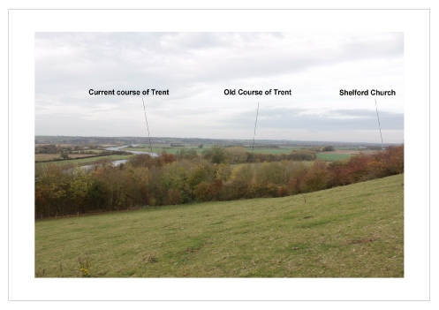
Photograph: The River Trent at Shelford-
This former route of the river seems to have been an original course according to this map.
But was this an original single channel of the river?
These answers can be found by using landscape archaeology techniques, and through examination of the other surviving sources.
The last perambulation of the boundary of Sherwood Forest from 1664 states:
‘and from thence it ascendeth up the River of Trent, near unto the Abbey or Mannour of Shelford. Soe that the said Abbey is without the Forrest, and from thence by the said water of Trent, where of ancient time it were wont to runne, thorough the meadows of Shelfoe Towne, on the South East part of the New Course now of Trent along, to the Mannour of Collwick, and there where the Trent was wont to run of old time, Soe that the Inclosure called Heylin is within the Forrest, and from thence by the said water of Trent, wherelsoe it antiently rann, downe unto Nottingham Bridge, alias Holl-
Interestingly the current course of the river is referred to here as ‘the New Course now of Trent’. The southern channel is described as ‘where of ancient time it were wont to runne through the meadows of Shelforde Towne’.
There were two branches of the Trent in the 17th century, the northern of which was the newer and the southern of which was the older.
But what about earlier, can we determine when the two channels formed?
We can look back to the late 16th century, and we see there were two channels then also.
In 1592 these channels would be the cause of a dispute taken all the way to the Star Chamber of Elizabeth I.
This was due to damming of the northern channel with a wier by Sir Thomas Stanhope. He even built locks to allow traffic through the more important northern course through a pound lock he constructed in 1577 between the island of ‘Prier Houlte’ and Shelford. (Salisbury 1982, Revill 1971). These locks are the oldest example known on the Trent.
The southern channel at this point was used for powering mills in the village.
The former island of ‘Prier Houlte’ and the location of the channel for the former pound lock is still visible on the ground.
It would appear then that there were two courses of the river by the 16th century.
The southern channel was no longer navigable by 1592 and was used for mills. Whereas the northern channel was therefore the main navigable route by this time, and would remain so from then onwards.
So did the course alter dramatically in the medieval period? Perhaps an event of flooding forced an entirely new course to the north? Or was there already a large meander to the north of the southern route?
Mapping evidence both modern and historic suggests the northern course of the river was in existence-
All the fields south of the current river channel (the northern course) belong to Shelford, suggesting the northern river course was there when the village was formed-
The exception is Burton Meadow (see map above-
Burton Meadow was originally connected to the rest of Burton parish, and this meander must have been cut off at the neck -
This would also suggest that the northern course was there in the early Medieval period.
The shape of this ancient meander around Burton Meadow accounts for the sudden right angle seen in the southern course of the Trent just to the north of Shelford. It was here that it originally joined the northern channel.
It would therefore seem that there were two courses of the Trent in the Medieval period at Shelford, the southern of which formed the Medieval boundary of Sherwood Forest, the northern of which formed the older parish boundaries.
Interestingly the medieval perambulations of Henry III and Edward I make no mention of two courses of the Trent.
Why is this?
It seems that wherever the boundary encountered more than one river channel it followed the external channel-
A similar situation occurred on the River Leen near Nottingham, where the river also had a number of courses.
The course furthest to the West was the one used as the boundary here.
The old course of the Trent at Shelford then, was not an original,single channel, but one of two courses-
It is amazing to think that this part of Nottinghamshire, the quit and sleepy village of Shelford, was once part of the world famous Sherwood Forest, and represents the only place where Sherwood Forest extends south over the River Trent into Southern Nottinghamshire.
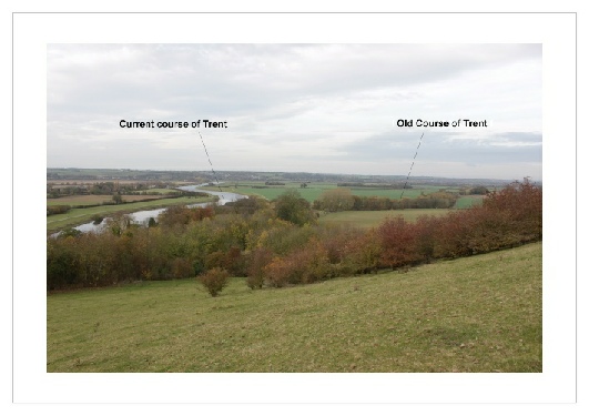
Photograph: The River Trent at Shelford-
(Andy Gaunt, first published 08/11/2011 -
Click here for more ‘Stories from the Forest’…
Why not click on the map below and explore the landscape described above.
The Future of Sherwood’s Past
Project page links:
-
-
-
-
-
-
-
-
The Sherwood Forest
National Nature Reserve Archaeology Survey
-
Long term Research at
King John’s Palace:
Ancient Royal Heart of Sherwood Forest
-
The Sherwood Forest Archaeology Training Fieldschool
-
“Scirwuda-
Ghost and Shadow woods of Sherwood Forest Project
-
Investigating Thynghowe Viking
Meeting Site
-
Searching for the
The Battle of Hatfield
-
-
Fieldswork at St Edwin’s Chapel
-
St Mary’s Norton-
-
Mapping Medieval Sherwood Forest
-
The Sherwood Forest LiDAR
Project
-
Warsop Old Hall
Archaeological Project
-
The Sherwood Villages Project:
Settlement Development in the Forest
-
-
-
Researching Edward IIs fortification at Clipstone Peel
-
-
-
-
The Cistercians of Rufford Project:
Settlement Development, Dynamics and Desertion.
-
Sherwood Forest Environmental Survey
-
World War II in Sherwood Forest -
-
World War I in Sherwood Forest -
-
About Medieval Sherwood Forest
-
Robin Hood and Sherwood Forest
-
-
-
-
-
-
-
-
-
-
-
-
Mercian Archaeological Services CIC (Community Interest Company)
An Independent Research Company, specialising in Training, Community Archaeology & Public Involvement.
Community Archaeology Nottinghamshire, Excavation, Research, Volunteering, Community Archaeology Derbyshire, Training, Social, Learning, Community Archaeology Leicestershire, Heritage, Involvement, Belonging, Knowledge sharing, Community Archaeology Lincolnshire, Topographic Survey, Talks and Presentations, Outreach, Archaeology Projects , Open Days, Schools, Finds Processing, Day Schools, Field Schools, Young People, Archaeology and History of Sherwood Forest, Pottery Research, Medieval, Roman, Prehistoric, Community Interest Company, Community Archaeology Nottinghamshire.
Community Archaeology in Nottinghamshire
Community Archaeology in Derbyshire
Community Archaeology in Leicestershire
Community Archaeology East Midlands
Community Archaeology in Lincolnshire
© Mercian Archaeological Services CIC 2019. Registered Business No. 08347842. All Rights Reserved.
Community Archaeology in Yorkshire
Project page links:
-
-
-
-
-
-
-
-
The Sherwood Forest
National Nature Reserve Archaeology Survey
-
Long term Research at
King John’s Palace:
Ancient Royal Heart of Sherwood Forest
-
The Sherwood Forest Archaeology Training Fieldschool
-
“Scirwuda-
Ghost and Shadow woods of Sherwood Forest Project
-
Investigating Thynghowe Viking
Meeting Site
-
Searching for the
The Battle of Hatfield
-
-
Fieldswork at St Edwin’s Chapel
-
St Mary’s Norton-
-
Mapping Medieval Sherwood Forest
-
The Sherwood Forest LiDAR
Project
-
Warsop Old Hall
Archaeological Project
-
The Sherwood Villages Project:
Settlement Development in the Forest
-
-
-
Researching Edward IIs fortification at Clipstone Peel
-
-
-
-
The Cistercians of Rufford Project:
Settlement Development, Dynamics and Desertion.
-
Sherwood Forest Environmental Survey
-
World War II in Sherwood Forest -
-
World War I in Sherwood Forest -
-
About Medieval Sherwood Forest
-
Robin Hood and Sherwood Forest
-
-
-
-
-
-
-
-
-
-
-
-