


Community Archaeology Nottinghamshire, Community Archaeology Derbyshire, Community Archaeology Leicestershire, Community Archaeology East Midlands, Mercian Archaeological Services Community Archaeology for Nottinghamshire, Derbyshire, Sherwood Forest, Leicestershire and the East Midlands. Community Archaeology Nottinghamshire, Community Archaeology East Midlands, Community Archaeology Leicestershire. Archaeological

The Saxons of Sherwood Forest
Award Winners 2016
for "Engaging people in the heritage, history & archaeology of Sherwood Forest".


Some funders and partners:
World-


Mercian Archaeological Services CIC
Specialists in Community Archaeology, Public Involvement, Research & Training
Community Archaeology Nottinghamshire, Excavation, Research, Volunteering, Community Archaeology Derbyshire, Training, Social, Learning, Community Archaeology Leicestershire, Heritage, Involvement, Belonging, Knowledge sharing, Community Archaeology Lincolnshire, Topographic Survey, Talks and Presentations, Outreach, Archaeology Projects , Open Days, Schools, Finds Processing, Day Schools, Field Schools, Young People, Archaeology and History of Sherwood Forest, Pottery Research, Medieval, Roman, Prehistoric, Community Interest Company, Community Archaeology Nottinghamshire.
Community Archaeology in Nottinghamshire
Community Archaeology in Derbyshire
Community Archaeology in Leicestershire
Community Archaeology East Midlands
Community Archaeology in Lincolnshire
© Mercian Archaeological Services CIC 2013. Registered Business No. 08347842. All Rights Reserved.
The oldest documented mention of 'Sherwood Forest' comes from a charter dating from 958AD granting Scrooby and Sutton cum Lound in north Nottinghamshire from the Crown to the Archbishop of York.
This charter lists a 'Scirwuda' (Shire Wood) as a boundary mark of the land granted to the Archbishop.
The area that would later become the royal hunting forest of Sherwood was shown to be covered in heathland, and wood-
It is just possible that this 958 charter indicates that there may have common pasture in the extensive wood-
The earliest boundary for the Forest of Nottingham listed for the time of Henry I ,in the early 12th century, would intersect with the ‘Scirwuda’ mentioned in this document.
So it is very possible that the Sirwuda mentioned in the 958 charter was the wooded common which formed the physical forest that was later brought within the ‘Legal Forest’ of the royal hunting grounds.
Whether this is true may have to remain a mystery.
So too perhaps will the people who lived in this landscape in these distant times.
We can however, get a glimpse of among their number who gave their names to some of the settlements and villages of the area.
Including Basford, meaning “Basa’s Ford”, and Blidworth, meaning “Blida’s farm”.
We can also learn something of the people of the Sherwood Forest area in later Saxon times.
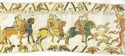
The names of some of the landowners from the time of the conquest are recorded in the Domesday book for Nottinghamshire. This great survey of William I was written in 1086, and gives us the names of the conquering Norman land-
It also lists the pre-
They are the names of the local ruling elite who would suffer by losing their lands in the change of power that came with the Norman Conquest.
Most of the landowners listed lost their posessions to the incoming Normans by the time that Domesday Book was written in 1086.
The following is a list of the towns and villages of the Forest, and the names of the original 'Saxon' landowners where they get a mention:
Nottingham: Earl Tosti (brother of Harold Godwinson who was King of England until the Battle of Hastings) owned land and buildings in the town.
Hugh son of Baldric was its sheriff.
In 1066 King Edward the Confessor held Manors and jurisdiction over land including: Mansfield, Arnold, Sneinton, Warsop, Budby and Edwinstowe,
The other listed landlords are as follows:
Annesley: Leofnoth,
Basford: Alwin, Aswulf, Alfeah, Aelfric and Algot,
Blidworth: the Archbishop of York (Ealdred),
Bulcote: Young Swein,
Bulwell: Aelmer and Godric,
Burton Joyce: Swein,
Calverton: Aelfric,
Caythorpe (Alwoldestorp): Athelstan,
Clipstone: Osbern and Wulfsi,
Clumber: Aethwold and Ulfkell,
Colwick: Godric, Aelfric and Bugg,
Gedling: Toki and Dunstan,
Gunthorpe: Morcar,
Lambley: Ulfketel,
Lenton: Wulfnoth,
Ollerton: Alfwold and Wada,
Papplewick: Aelfric, Alfsi and Alric,
Perlethorpe: Thurstan and Wulfmer,
Radford: Aelfric,
Rufford: Ulf,
Stoke Bardolph: Toki,
Warsop: Godric, Leofgeat and Ulfkell,
Woodborough: Ulfkell, Aelfric, Wulfgeat, Wulfric and Alfsi,
(Ref: all names compiled from Morris 1977)
These names sound ancient and archaic (but also poetic and beautiful) to us now.
That is compounded by the fact that the names that replaced them at the Norman Conquest are so much more familliar to us.
Henry, John, Richard, William, Stephen, were all names of the Norman and Angevin kings who ruled between them from 1066 to 1272.
All these names were French.
Edward I, crowned in 1272 was the first English King since 1066 to carry an English name.
In Nottinghamshire these name would be replaced powerful Norman landowners including a Roger or two, an Alan, a William, a Walter, three Ralphs, and a handful of Gilberts, to name a but a few.
Although we can't know the characters or the actions of these English rulers-
This change of authority and culture had a great impact on English Society as a whole.
Locally it would bring with it the Laws of the Forest that would have a huge impact on the landscape and the people of this area.
The area that would become Medieval Sherwood Forest.
The Future of Sherwood’s Past
Project page links:
-
-
-
-
-
-
-
-
The Sherwood Forest
National Nature Reserve Archaeology Survey
-
Long term Research at
King John’s Palace:
Ancient Royal Heart of Sherwood Forest
-
The Sherwood Forest Archaeology Training Fieldschool
-
“Scirwuda-
Ghost and Shadow woods of Sherwood Forest Project
-
Investigating Thynghowe Viking
Meeting Site
-
Searching for the
The Battle of Hatfield
-
-
Fieldswork at St Edwin’s Chapel
-
St Mary’s Norton-
-
Mapping Medieval Sherwood Forest
-
The Sherwood Forest LiDAR
Project
-
Warsop Old Hall
Archaeological Project
-
The Sherwood Villages Project:
Settlement Development in the Forest
-
-
-
Researching Edward IIs fortification at Clipstone Peel
-
-
-
-
The Cistercians of Rufford Project:
Settlement Development, Dynamics and Desertion.
-
Sherwood Forest Environmental Survey
-
World War II in Sherwood Forest -
-
World War I in Sherwood Forest -
-
About Medieval Sherwood Forest
-
Robin Hood and Sherwood Forest
-
-
-
-
-
-
-
-
-
-
-
-