Medieval Sherwood Forest was criss-
It is perhaps the presence of such roads, and the fearful journeys along them that helped fuel the many legends of hooded outlaws roaming the woods.
The King’s Highway to York ran from Nottingham up the eastern side of the forest. This important road took traffic north and south under the watchful eye of Nottingham Castle, the strategic castle perched on its lofty cliffs of sandstone close to the crossing of the River Trent.
Thee other great highway passing north and south through Sherwood Forest ran up the western side from Nottingham to the great royal manor of Mansfield.
A third major road ran along the southern edge of the forest, following the northern bank of the River Trent, hugging the bottom of the Clay ridge of the Mercia Mudstones, taking traffic from Nottingham to the Archbishop of York’s manor at Southwell-
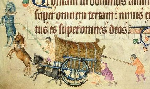
Picture: A medieval cart -
Alongside these major highways were a large number of smaller roads which travelled across the forest.
Some of them were ‘Pack mans’ ways-
There also other medium sized route ways providing cart track ways between settlements.
Many of these road s are listed on a late 14th century or early 15th century map of the Forest.
Some of these carry descriptive names such as:
‘ye ryge (ridge) way’,
And
‘ye brome (the broom) gate’ (from Gata meaning road in Old Scandinavian).
Others carried the name of the settlement through which they passed, or were near to:
‘Papulwyk (Papplewick) Way’,
and
‘ye roide of Buluel' (the road of Bulwell).
One road is named ‘Egmanton Way’ after the viallge of Egmanton on the eastern edge of Sherwood Forest.
However there is a puzzle as to why it carries this name, as is not shown as being in or near to the village of Egmanton at all.
Egmanton village lay four miles to the east of the 13th century forest boundary near to the larger and more prominent village of Laxton.
Egmanton had a Motte and Bailey Castle in its centre , but was considerably smaller in stature as a village than its neighbour at the time.
Laxton had been the seat of the keepers of Sherwood Forest since the De Caux dynasty, who were hereditary keepers through marriage into the D’Everingham family up until the late 13th century.
Laxton had been remodelled during this time and may well have had pretensions of becoming a market town (Challis 1994), until keepership was stripped from the D’Everinghams for breaking the very Forest Laws they were in post to oversee.
Any road heading in that direction, at that time, would most likely have been called ‘Laxton Way’ not not have been named after the less important village of Egmanton.
So what reason could there be for the name of the road ‘Egmanton Way’?
The location of Egmanton, and the relative positioning of the name on the Belvoir Map suggests it ran from a location to the south-
It is important therefore to understand where the road may have been leading to Egmanton from…
To the south-
Newstead was home to a community of Augustinian Priors who were known as the ‘Priors of Sherwood Forest’.
They were granted lands around Nottinghamshire for their Priory at Newstead-
As time passed many more parcels of land and other offerings were granted to the priory.
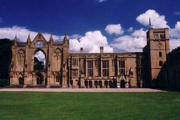
Picture: Newstead Abbey, Nottinghamshire. Formerly a medieval priory of Augustinian Canons.
The Newstead Cartulary of 1344 contains record of the land granted to the Priory by people wishing to secure a place in heaven, and eternal peace.
One such entry is a licence to appropriate the Church of Egmanton on 31st October 1315:
‘Edward by the grace of God King of England, Lord of Ireland, and Duke of Aquitaine, to all to whom the present letters shall come, greeting. Know ye that of our special grace we have granted and given licence on behalf of us and our heirs, as far as in us lies, to our beloved in Christ, the Prior of Newstead in Shyrewode, and the Convent of the same place, that they themselves may appropriate the church of Egmanton, in the diocese of York, which is of their own advowson, and having appropriated it, may hold it to their own use for themselves and their successors for ever, without annoyance or hindrance by us or our heirs, Justices, Escheators, Seriffs, or others our Bailiffs or Ministers whomsoever. The statute of Mortmain notwithstansding. In witness thereof we have had these our letters made patent. As witness myself at Clypston, the thirty-
(Gray (Ed.) 1940).
Notice that Edward II was staying at his favoured royal retreat at Clipstone (see King John's Palace page for more details).
So the Priors of Newstead owned the church at Egmanton from 1315 onwards (actually 1329, see below).
It would seem likely then that the name of the road reflects this land grant by King Edward II to the Priors of Sherwood-
But why would the church at Egmanton be of such significance to the monks of Newstead, and why were they granted the church?
The reason lies in the financial hardship that was being endured by the Priors in the early 14th century.
Also in the presence at Egmanton of a shrine, which was the centre for pilgrimage.
To put it bluntly in medieval times pilgrimage meant money.
At some time prior to the 12th century it is reported that an apparition of the Virgin Mary appeared to a local woman in the nearby hamlet of Ladywood, close to Egmanton.
A shrine of ‘Our Lady of Egmanton’ was subsequently founded in the parish church, and remained there until it was destroyed in 1547, as part of the English Reformation, which saw the dissolution of the monasteries and the closing of chantries and shrines.
.jpg)
Picture: Church of Our Lady of Egmanton, Egmanton, Nottinghamshire. Figure of the Virgin and Child at the top of the organ case. Photo © Alan Murray-
“This shrine attracted many pilgrims from far and wide who visited the church, which thus became more than just a parish church. Many of the pilgrims scratched crosses into the stone of the south door and north aisle to mark their pilgrimage and many of these cuttings can still be seen today.”
(http://southwellchurches.history.nottingham.ac.uk/egmanton/hhistory.php)
Pilgrims from the north would traditionally use Egmanton as a stopping-
The following exert from the Southwell and Nottinghamshire Church History Project-
“One of the earliest references to Egmanton ‘chapel’ (Eggemonton) appears in a charter of John, Count of Mortain dated 1191x1193 that describes the gift of the chapelry of Blyth, with all its appurtenances, which includes Egmanton, to the cathedral church of the blessed Mary of Rouen.
In 1252 the Papal Letters record that the rectory was valued at 8 marks (£5 6s 8d) when Master Richard de Chireburne, then rector, was granted licence to hold an additional benefice by Pope Innocent IV.
The church was originally in the patronage of the De Eyville (D’Aville) family, the Lords of Egmanton, who acquired the village from Nigel d’Albini in the reign of Henry I, and may have sponsored its construction or at least its development from a chapel to a parish church. It was passed down the family until the reign of Henry III in the early 13th century, when Sir John de Eyville (who would go on to be a leading rebel against the king in the Second Baron’s War) gifted the patronage of the church to the Priory of Newstead, which belonged to the Augustinian Canons. In 1291 the church, still with the priory as patrons, was valued at £10 in a religious tax of that year, a surprisingly small amount given the additional donations the pilgrimages must have provided.
In 1315 there was an incident whereby the church and manse were forcibly entered during a vacancy following the death of Roger de Bergh, the previous rector. Archbishop Greenfield issued a mandate to the Dean of Retford to denounce and excommunicate those persons who had committed this crime.
The priory at Newstead struggled financially through much of its existence. In response to a plea for financial assistance, Edward II granted the priory a royal licence in 1315, permitting it to appropriate Egmanton Church to the priory, bringing it, and its income directly under the control of the Augustinians. However the appropriation did not take place then due to opposition from the Archbishop of York, William Melton. In the end Papal letters had to be issued in 1326-
The reason given for the appropriation is the poor state of the priory due to its distance from any villages and its position along the public road meaning many travellers would use the priory to rest for the night. The church was appropriated but the priory was expected to appoint a perpetual vicar to Egmanton, to construct a hall, chamber, and kitchen for his habitation and to allocate 20 acres of arable and 3 acres of meadow land as well as the mortuary tithes and all other small tithes to support him. The priory also had to pay an annual pension of 6s 8d to the archbishop and his successors.
Interestingly, in a writ of 1342, the church of Egmanton was still being referred to as a ‘chapel’ and there is confirmation that it was ‘not alienated by Walter, sometime archbishop of Rouen, his canons or their successors’.
In 1341 the church was valued at 12 marks (£8) for the ninths of sheaves, lambs, and their fleeces in the Nonarum Inquisitions – a religious tax of that year. The church also had 11 acres of land attached to it (noticeably less than half what the 1329 decree had ordered), worth 30s a year, and received both tithes of hay worth 10s and mortuary offerings worth 26s 6d; a total of £11 6s 6d. No mention is given of the impact of the shrine and pilgrimages on the church or how much of this income went instead to the priory rather than being used for Egmanton itself, particularly when compared to what was supposed to go to Egmanton’s vicar. In 1428 a later tax showed Egmanton had the same value as in 1291, £10.
In 1531 Richard Cuxton, a local gentleman, asked in his will that his soul be given ‘to God Almighty, St Mary and All Saints, and his body to be buried in the Church of Our Blessed Lady of Egmanton’. Such would have been a common occurrence, especially given the holiness imbued by the shrine of the Virgin Mary. Donations were also common – three years after this John Marshall, the rector at South Wheatley, bequeathed 3s 4d to the church.
The Reformation brought dramatic changes to the Church in England, and Egmanton was no exception. After Henry VIII seized control of the English Church he made great efforts to close down the priories and abbeys and confiscate their wealth, and as part of this surveyed these institutions to judge their value. Egmanton was valued at £8 13s 4d, which made it the richest of Newstead’s six attached rectories. Although the priory managed to avoid closure initially by paying a heavy fine the delay was brief and in 1539 the priory at Newstead was suppressed. Soon after Sir John Byron (ancestor to the famous poet) purchased the priory along with all its lands and advowsons. Although the priory building remained in the Byron family for three hundred years the church at Egmanton was at some point sold on. The records for 1546 state that Robert and Hugh Thornehill had petitioned to purchase the parsonage of Egmanton from John Bellowes, who had licence to alienate the rectory and church.
The Reformation also resulted in the closure and destruction of the Marian shrine at Egmanton in 1547. For the next four hundred years there were no pilgrims travelling to visit the church, which now became just an ordinary parish church.”
(http://southwellchurches.history.nottingham.ac.uk/egmanton/hhistory.php)
This is an insight into how the actions of the powers of the land could impact on even the smallest aspect of the life and landscape of the forest.
It also solves the puzzle as to how ‘Egmanton Way’ linked the Priors of Sherwood with the a pilgrimage site to the Virgin Mary, on the other side of the Forest.
(Andy Gaunt, first published 10/11/2011, updated 02/04/2020)
Click here for more ‘Stories from the Forest’…
Why not Explore Egmanton and nearby Laxton via the map below.


Community Archaeology Nottinghamshire, Community Archaeology Derbyshire, Community Archaeology Leicestershire, Community Archaeology East Midlands, Mercian Archaeological Services Community Archaeology for Nottinghamshire, Derbyshire, Sherwood Forest, Leicestershire and the East Midlands. Community Archaeology Nottinghamshire, Community Archaeology East Midlands, Community Archaeology Leicestershire. Archaeological

Egmanton Way: The Virgin Mary, Priors, and Pilgrimage in Medieval Sherwood Forest
Award Winners 2016
for "Engaging people in the heritage, history & archaeology of Sherwood Forest".


Some funders and partners:
World-



The Future of Sherwood’s Past
Project page links:
-
-
-
-
-
-
-
-
The Sherwood Forest
National Nature Reserve Archaeology Survey
-
Long term Research at
King John’s Palace:
Ancient Royal Heart of Sherwood Forest
-
The Sherwood Forest Archaeology Training Fieldschool
-
“Scirwuda-
Ghost and Shadow woods of Sherwood Forest Project
-
Investigating Thynghowe Viking
Meeting Site
-
Searching for the
The Battle of Hatfield
-
-
Fieldswork at St Edwin’s Chapel
-
St Mary’s Norton-
-
Mapping Medieval Sherwood Forest
-
The Sherwood Forest LiDAR
Project
-
Warsop Old Hall
Archaeological Project
-
The Sherwood Villages Project:
Settlement Development in the Forest
-
-
-
Researching Edward IIs fortification at Clipstone Peel
-
-
-
-
The Cistercians of Rufford Project:
Settlement Development, Dynamics and Desertion.
-
Sherwood Forest Environmental Survey
-
World War II in Sherwood Forest -
-
World War I in Sherwood Forest -
-
About Medieval Sherwood Forest
-
Robin Hood and Sherwood Forest
-
-
-
-
-
-
-
-
-
-
-
-
Mercian Archaeological Services CIC (Community Interest Company)
An Independent Research Company, specialising in Training, Community Archaeology & Public Involvement.
Community Archaeology Nottinghamshire, Excavation, Research, Volunteering, Community Archaeology Derbyshire, Training, Social, Learning, Community Archaeology Leicestershire, Heritage, Involvement, Belonging, Knowledge sharing, Community Archaeology Lincolnshire, Topographic Survey, Talks and Presentations, Outreach, Archaeology Projects , Open Days, Schools, Finds Processing, Day Schools, Field Schools, Young People, Archaeology and History of Sherwood Forest, Pottery Research, Medieval, Roman, Prehistoric, Community Interest Company, Community Archaeology Nottinghamshire.
Community Archaeology in Nottinghamshire
Community Archaeology in Derbyshire
Community Archaeology in Leicestershire
Community Archaeology East Midlands
Community Archaeology in Lincolnshire
© Mercian Archaeological Services CIC 2019. Registered Business No. 08347842. All Rights Reserved.
Community Archaeology in Yorkshire
Project page links:
-
-
-
-
-
-
-
-
The Sherwood Forest
National Nature Reserve Archaeology Survey
-
Long term Research at
King John’s Palace:
Ancient Royal Heart of Sherwood Forest
-
The Sherwood Forest Archaeology Training Fieldschool
-
“Scirwuda-
Ghost and Shadow woods of Sherwood Forest Project
-
Investigating Thynghowe Viking
Meeting Site
-
Searching for the
The Battle of Hatfield
-
-
Fieldswork at St Edwin’s Chapel
-
St Mary’s Norton-
-
Mapping Medieval Sherwood Forest
-
The Sherwood Forest LiDAR
Project
-
Warsop Old Hall
Archaeological Project
-
The Sherwood Villages Project:
Settlement Development in the Forest
-
-
-
Researching Edward IIs fortification at Clipstone Peel
-
-
-
-
The Cistercians of Rufford Project:
Settlement Development, Dynamics and Desertion.
-
Sherwood Forest Environmental Survey
-
World War II in Sherwood Forest -
-
World War I in Sherwood Forest -
-
About Medieval Sherwood Forest
-
Robin Hood and Sherwood Forest
-
-
-
-
-
-
-
-
-
-
-
-