Medieval Sherwood Forest was a landscape of woodland, heathland, towns and villages.
It was an ideal location for a Royal Forest because it was underlain for the most part by sandstone bedrock (see why Sherwood Page for more details on the location of Sherwood).
There were other rocks underlying the forest including the Magnesian Limestones group and the Mercia Mustones. But the forest sat predominantly on the group of sandstones laid down in the Triassic Period 250-
Picture: Sherwood Sandstones under Nottingham Castle
They were formed as flash-
They were however renamed the ‘Sherwood Sandstones’ because of their link to the medieval forest.
The sandstones were highly permeable, resulting in leaching of nutrients from the over lying soils. The result was that this landscape was less suitable for arable in the medieval period, than the surrounding geologies and so maintained a relatively higher amount of woodland and lowland heath (see why Sherwood page)
Ideal for deer and hunting.
Another property of the Sherwood Sandstones was that they could be dug into using hand tools. The sandstone were relatively week and friable (easily scraped away) but thanks to a clay cement they could be shaped into self-
As a result Nottingham, but also to a lesser extent Mansfield (rock houses) had an incredible array of rock-
Some of the caves of Nottingham and their use in the medieval period will be discussed here. There are many many caves in Nottingham-
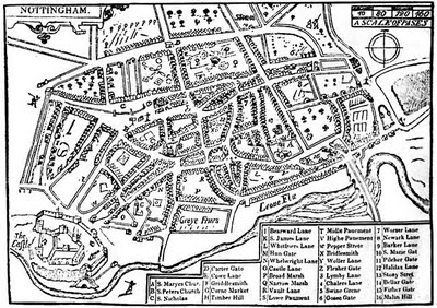
In Medieval times there were many caves in Nottingham-

Picture: John Speeds Map of Nottingham 1610
Further south of this the rock was beneath the water-
Many of the caves that may have existed in medieval times have either been re-
Contrary to popular legend and myth the caves did not form tunnels down which Robin Hood avoided capture by the Sheriff of Nottingham-
They generally formed cellars under buildings-
Brewing was a large industry during medieval times and some of the surviving caves are Maltkilns, where spherical rooms were carved into the sandstone with either a continuous ledge around the edge or notches cut to support beams to hold the grain which was roasted from charcoal fires beneath (Waltham 2008).
Booze and boozing has always been popular in England and it was no different in medieval Sherwood Forest where as well as a legitimate brewing industry, demand must have out-
Another major industry in Sherwood Forest was tanning (turning raw animal hide into leather). The oak bark from the forest provided a perfect ingredient for the process-
A number of tanners are listed in the Nottingham Borough records and other sources, including a Willelmo le Tanur (William the Tanner) from 1222-
Evidence of the use of oak bark in the industry is still preserved in the name ‘Barker Gate’ a street in the later Lace Market area of the old town-
In the presentments of the Mickeltorn Jury for 1395 it is claimed that:
‘the tanners (tannarii) of Nottingham sell leather not well tanned, and that each of them sells leather in his house without the view of the market or being placed in the market for sale.’
The tannery caves of Nottingham were located to the southern side of town and were cut into the base of the cliff.
Picture: Nottingham Tannery Cave -
The process used vats cut into the bedrock to allow fluids for different parts of the process to be held.
They are the only underground tanneries in Britain and must have stunk to high heaven!
In the 1395 Mickeltorn Jury presentments it is later stated that the ‘tanners dwelling in Littlemerche (Littlemarsh) of Nottingham on the southern side block up the common water which is called Lene with stakes, poles and turves in time, and lay their leather in the aforesaid water'.
Tanners along with dyers and fullers were commonly in trouble with this court as the people of Nottingham complained about the smells and ‘odure’ associated with their trades.
This relationship, however uneasy, had a long history and was also in existence in the 13th century and earlier:
One of the tannery caves contained a cess pit in the tannery floor which contained pottery from 1270-
Caves were also used as dwelling places, possibly around the base of Castle Rock, and on the main holloway road ways into the town (Derby Road and Hollowstone)-
Maybe one of these caves provided shelter for William Leech and Thomas Kay who ‘unjustly occupied the King’s Highway under the cemetery of the Church of the Blessed Mary’ in 1395.
Cellars were used for the storage of wool and other commodities (Waltham 2008) a number of occurrences of these being left open to the road are recorded including a William Dalahowe who ‘holds a cellar open at the corner towards mothalgate (moot hall gate) to the serious detriment of the town' also in 1395.
Alongside these caves that were part of the everyday life of the townscape of Nottingham there were a number of larger caves in the rock under Nottingham Castle that were involved in events of national importance.
Nottingham Castle sits atop a steep sided sandstone bluff overlooking the town and dominating the river valleys to the south and west (see Medieval Nottingham Castle entry).
One of the most famous caves cut within the rock is known as 'King Davids Dungeon' and may have held King David II of Scotland in the 14th century.
The most famous cave in Nottingham is Mortimers Hole-
It was through this tunnel that Edward III’s men broke into Nottingham Castle in 1334 and captured the usurper Roger Mortimer-
All in Nottingham Castle in medieval Sherwood Forest.
The caves of Nottingham then, were an intrinsic part of day to day life in the heart of medieval Sherwood Forest, and as well as giving us a glimpse into how people lived their lives they also sometimes played their part in the lives of the great and good, and on the lives of the people of medieval England as a whole.
The caves of Nottingham, are one of the lesser known secrets of Nottingham and Sherwood Forest, and hopefully with these new archaeological projects and potential redevelopment as a bigger tourist attraction their history will become known to a wider audience.
Andy Gaunt, first published 18/02/2012)
Click here for more ‘Stories from the Forest’…


Community Archaeology Nottinghamshire, Community Archaeology Derbyshire, Community Archaeology Leicestershire, Community Archaeology East Midlands, Mercian Archaeological Services Community Archaeology for Nottinghamshire, Derbyshire, Sherwood Forest, Leicestershire and the East Midlands. Community Archaeology Nottinghamshire, Community Archaeology East Midlands, Community Archaeology Leicestershire. Archaeological

The Caves of Medieval Sherwood Forest
Award Winners 2016
for "Engaging people in the heritage, history & archaeology of Sherwood Forest".


Some funders and partners:
World-


Mercian Archaeological Services CIC
Specialists in Community Archaeology, Public Involvement, Research & Training
Community Archaeology Nottinghamshire, Excavation, Research, Volunteering, Community Archaeology Derbyshire, Training, Social, Learning, Community Archaeology Leicestershire, Heritage, Involvement, Belonging, Knowledge sharing, Community Archaeology Lincolnshire, Topographic Survey, Talks and Presentations, Outreach, Archaeology Projects , Open Days, Schools, Finds Processing, Day Schools, Field Schools, Young People, Archaeology and History of Sherwood Forest, Pottery Research, Medieval, Roman, Prehistoric, Community Interest Company, Community Archaeology Nottinghamshire.
Community Archaeology in Nottinghamshire
Community Archaeology in Derbyshire
Community Archaeology in Leicestershire
Community Archaeology East Midlands
Community Archaeology in Lincolnshire
© Mercian Archaeological Services CIC 2013. Registered Business No. 08347842. All Rights Reserved.
The Future of Sherwood’s Past
Project page links:
-
-
-
-
-
-
-
-
The Sherwood Forest
National Nature Reserve Archaeology Survey
-
Long term Research at
King John’s Palace:
Ancient Royal Heart of Sherwood Forest
-
The Sherwood Forest Archaeology Training Fieldschool
-
“Scirwuda-
Ghost and Shadow woods of Sherwood Forest Project
-
Investigating Thynghowe Viking
Meeting Site
-
Searching for the
The Battle of Hatfield
-
-
Fieldswork at St Edwin’s Chapel
-
St Mary’s Norton-
-
Mapping Medieval Sherwood Forest
-
The Sherwood Forest LiDAR
Project
-
Warsop Old Hall
Archaeological Project
-
The Sherwood Villages Project:
Settlement Development in the Forest
-
-
-
Researching Edward IIs fortification at Clipstone Peel
-
-
-
-
The Cistercians of Rufford Project:
Settlement Development, Dynamics and Desertion.
-
Sherwood Forest Environmental Survey
-
World War II in Sherwood Forest -
-
World War I in Sherwood Forest -
-
About Medieval Sherwood Forest
-
Robin Hood and Sherwood Forest
-
-
-
-
-
-
-
-
-
-
-
-