

Outdoor Archaeological Training Courses
Community Archaeology Nottinghamshire, Community Archaeology Derbyshire, Community Archaeology Leicestershire, Community Archaeology East Midlands, Mercian Archaeological Services Community Archaeology for Nottinghamshire, Derbyshire, Sherwood Forest, Leicestershire and the East Midlands. Community Archaeology Nottinghamshire, Community Archaeology East Midlands, Community Archaeology Leicestershire. Archaeological
At Mercian we offer a variety of ‘outdoor’ courses which are predominantly field-
Current schools include:


Click on the links above to view each training course in turn and follow links to the individual pages to see which course most suits your requirements and preference

In archaeology the ability to measure the location of a site, artefact, or earthwork is essential.
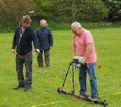
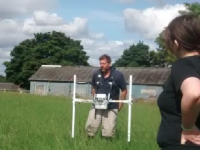
Nowadays many archaeological sites use either GPS or Total Station for site survey. Differential GPS can record points of circa 1cm accuracy levels in three dimensions, and can also allow real time ‘on the fly’ measurements to be taken allowing large areas of land to be surveyed. The total station is an electronic theodolite and Electronic Distance Measurer that records point locations by measuring distance and angles.
This course will teach the required skills that are used on excavations and other sites for locating features using GPS and total Station.
The course will also go further to enable participants to learn the complex skills of archaeological topographic survey, recording a site with a combination of both objective and subjective survey methods.
Topographic Survey Training day course aims to help participants learn about the theory, science, uses, methods, logistics, deployment, data collection, data processing, and reporting, behind archaeological topographic surveying.
The course will include a mixture of classroom and field based working. This is a field based training course consisting of hands-
The course will include:
- Introduction and theory, working in grids, mapping in 2 D and 3D, working with co-
ordinates and heights, ‘X,Y, & Z’, - Pythagoras and Right Angles,
- Levelling heights in ‘Z’,
- Laying out a trench from Ordnance Survey co-
ordinates - ‘X & Y’, - Introduction to Total Station & GPS,
- Undertaking the survey -
data collection, including control points, total station survey and cross- sections with a dumpy level. - Introduction to mapping in 3D with a Dumpy Level.
- Downloading data,
- Introduction to 2D mapping,
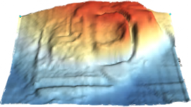
- Creating a Digital Terrain Model in GIS.
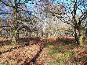
Students will meet at at King John’s Palace in Clipstone. The training will take place at the site of the Palace, and a survey will be undertaken in Sherwood Forest National Nature Reserve. Full details of the site will be provided nearer the time, but will be within 2 miles of King John’s Palace (transport from the classroom sessions to the field will be provided if required).
The survey training will begin at King John’s Palace, former royal heart of Sherwood Forest, and then move to the Sherwood Forest National Nature Reserve where earthworks from Medieval Holloways and ridge and furrow to Second World War Military dug-
As well as being a training survey, this course will undertake real archaeological research, mapping and recording earthworks as part of a level two survey of archaeological features as part of the Sherwood Forest National Nature Reserve Archaeological Survey.
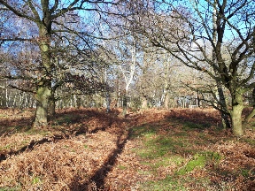
Ancient track-
Learning to survey with Total Station at King John’s Palace
As well as offering the best in archaeological training and support, the topographic survey course is tailored towards enabling attendees to fulfil requirements of the Archaeological Skills Passport.

Take your skills to the next level by joining our week long
Topographic Survey Training Course 2021
Kings John’s Palace
and the Sherwood Forest National Nature Reserve, Nottinghamshire.
Price £250 per person


The Major Oak legendary hideaway of Robin Hood in Sherwood Forest

2021 Dates:
Week of
11th -
£250 per person
Archaeological Geophysics uses a range of instruments and techniques to detect and map variations below the ground surface. These can be interpreted by archaeologists and effectively enable the experienced practitioner to ‘see’ possible archaeological features under the ground.
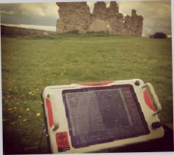
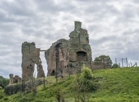
On this course delegates will undertake geophysical Resistance survey, Magnetometer survey, and Ground Penetrating Radar survey. At the remains of Codnor Castle in Derbyshire.
The course will include a mixture of classroom and field-
On this course delegates undertake the work in groups and collect real data in the field.
Delegates will then learn how to download data and how to process it.
There will also be chance to learn about how this data can be used in GIS (Geographic Information Systems) software, to produce maps ad plans.
The course will include:
- Introduction and theory,
- Laying out grids for surveying,
- Geophysical Resistance survey,
- Geophysical Magnetometer survey,
- Ground Penetrating Radar survey,
- Recording the location of grids,
- Downloading data,
- Working with geophysical data in GIS (Geographic Information Systems)
Magnetometer Survey
Resistance Survey
Ground Penetrating Radar Survey
Take your skills to the next level by joining our week long
Geophysical Survey Training Course 2021
at Codnor Castle, Derbyshire.
Price £250 per person
As well as offering the best in archaeological training and support, the geophysical survey training course is tailored towards enabling attendees to fulfil requirements of the Archaeological Skills Passport.
2021 Dates:
Week of
17th -
£250 per person
Mercian Archaeological Services CIC
Specialists in Community Archaeology, Public Involvement, Research & Training
Community Archaeology Nottinghamshire, Excavation, Research, Volunteering, Community Archaeology Derbyshire, Training, Social, Learning, Community Archaeology Leicestershire, Heritage, Involvement, Belonging, Knowledge sharing, Community Archaeology Lincolnshire, Topographic Survey, Talks and Presentations, Outreach, Archaeology Projects , Open Days, Schools, Finds Processing, Day Schools, Field Schools, Young People, Archaeology and History of Sherwood Forest, Pottery Research, Medieval, Roman, Prehistoric, Community Interest Company, Community Archaeology Nottinghamshire.
Community Archaeology in Nottinghamshire
Community Archaeology in Derbyshire
Community Archaeology in Leicestershire
Community Archaeology East Midlands
Community Archaeology in Lincolnshire
Community Archaeology in Yorkshire
© Mercian Archaeological Services CIC 2020. Registered Business No. 08347842. All Rights Reserved.
*Please note that while aspects of this course will be in-
*Please note that while aspects of this course will be in-
To be cofirmed soon