Community Archaeology Nottinghamshire, Community Archaeology Derbyshire, Community Archaeology Leicestershire, Community Archaeology East Midlands, Mercian Archaeological Services Community Archaeology for Nottinghamshire, Derbyshire, Sherwood Forest, Leicestershire and the East Midlands. Community Archaeology Nottinghamshire, Community Archaeology East Midlands, Community Archaeology Leicestershire. Archaeological

Coal Mining Heritage in Sherwood Forest
The Future of Sherwood’s Past
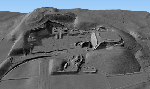
Picture: 3D visualisation of the site of the former Thoresby colliery at Edwinstowe, seen from the South.
LiDAR Composite DTM -
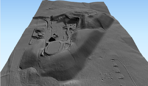
Picture: 3D visualisation of the site of the former Thoresby colliery at Edwinstowe, seen from the East.
LiDAR Composite DTM -
A project examining the physical and cultural impact of the coal mining industry on the landscape of Sherwood Forest.
The ‘black gold’ rush of the 20th century saw the landscape and people of Sherwood Forest change dramatically.
Coal mining brought collieries, winding engines, pit-
It also brought people from all over the country to work in the mines, and settle in the Forest. Coal miners and their families came and settled in Sherwood Forest, along with people to run the infrastructure and workings of the industry, and new communities. Changing the population and people of the Forest forever.
The 20th century saw the development of many ‘New’ villages and many ‘model’ villages built often with similar street patterns and housing. 1st Avenue, 2nd Avenue and more can be seen in many of these new towns around the Forest. These sat side-
The mines brought prosperity but also industrial scarring, which changed the landscape forever.
It would be fair to say that since the end of the medieval Forest Laws and the crowns management of the landscape; even considering the effects of the World Wars, the arrival of the Forestry Commission and the new pine plantations, and the efforts of the Dukeries Estates, nothing had a bigger impact on the modern landscape and culture of Sherwood Forest than the arrival of the coal mining industry, and its subsequent demise.
Following the collapse of the industry, these villages now have to re-
The former railway line embankments which cross the landscape, offer opportunities for green corridors of connectivity and public footpaths, and the former pit tips are being re-
How to best utilise the remains of this industry, both culturally and in the landscape forms some of the biggest challenges, but also opportunities for re-
Utilising LiDAR data and aerial photography, the ‘Coal Mining in Sherwood Forest’ project is mapping the impact on the landscape.
The project also has the long-
Project page links:
-
-
-
-
-
-
-
-
The Sherwood Forest
National Nature Reserve Archaeology Survey
-
Long term Research at
King John’s Palace:
Ancient Royal Heart of Sherwood Forest
-
The Sherwood Forest Archaeology Training Fieldschool
-
“Scirwuda-
Ghost and Shadow woods of Sherwood Forest Project
-
Investigating Thynghowe Viking
Meeting Site
-
Searching for the
The Battle of Hatfield
-
-
Fieldswork at St Edwin’s Chapel
-
St Mary’s Norton-
-
Mapping Medieval Sherwood Forest
-
The Sherwood Forest LiDAR
Project
-
Warsop Old Hall
Archaeological Project
-
The Sherwood Villages Project:
Settlement Development in the Forest
-
-
-
Researching Edward IIs fortification at Clipstone Peel
-
-
-
-
The Cistercians of Rufford Project:
Settlement Development, Dynamics and Desertion.
-
Sherwood Forest Environmental Survey
-
World War II in Sherwood Forest -
-
World War I in Sherwood Forest -
-
About Medieval Sherwood Forest
-
Robin Hood and Sherwood Forest
-
-
-
-
-
-
-
-
-
-
-
-
Community Archaeology in Derbyshire
Community Archaeology in Leicestershire
Community Archaeology Nottinghamshire, Excavation, Research, Volunteering, Community Archaeology Derbyshire, Training, Social, Learning, Community Archaeology Leicestershire, Heritage, Involvement, Belonging, Knowledge sharing, Community Archaeology Lincolnshire, Topographic Survey, Talks and Presentations, Outreach, Archaeology Projects , Open Days, Schools, Finds Processing, Day Schools, Field Schools, Young People, Archaeology and History of Sherwood Forest, Pottery Research, Medieval, Roman, Prehistoric, Community Interest Company, Community Archaeology Nottinghamshire.
Community Archaeology in Nottinghamshire
Community Archaeology East Midlands
Community Archaeology in Lincolnshire
Community Archaeology in Yorkshire
Mercian Archaeological Services CIC
Specialists in Community Archaeology, Public Involvement, Research & Training
© Mercian Archaeological Services CIC 2024. Registered Business No. 08347842. All Rights Reserved.